 Filter: Subject of peninsulas
Filter: Subject of boats and boating
Filter: Subject of peninsulas
Filter: Subject of boats and boating
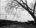
| Date: | 05 05 1931 |
|---|---|
| Description: | View across Lake Mendota towards Picnic Point, framed by a willow tree, and a rowboat pulled up on the shoreline. |
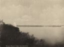
| Date: | 1900 |
|---|---|
| Description: | Picnic Point from shoreline of Lake Mendota at the University of Wisconsin-Madison campus. There is a university building on the hill on the left, and a pi... |

| Date: | |
|---|---|
| Description: | People gather on the bank of Picnic Point, a tree-covered peninsula surrounded by water. A man and two children paddle a canoe along the shoreline. |

| Date: | 06 10 1954 |
|---|---|
| Description: | Members of the University of Wisconsin male crew row on Lake Mendota. Picnic Point is in the background. |

| Date: | 2000 |
|---|---|
| Description: | This map shows national parks, county and state forests, Indian reservations, municipal land, private land, docks, boat access, camping, and points of inte... |

| Date: | 1980 |
|---|---|
| Description: | Aerial shot directly over Picnic Point. Boats are in the lake. Text on reverse reads: "Picnic Point — A peninsula of the University of Wisconsin campus jut... |
| Date: | 1915 |
|---|---|
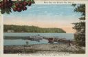
| Description: | Caption reads: "Sister Bay, near Sturgeon Bay, Wis." and "In Door County 'Cherryland,' the Nation's Largest Cherry Producer." Sister Bay from a rocky beach... |

| Date: | 1904 |
|---|---|
| Description: | Text on front reads: "The Hogs Back, Tomahawk, Wis." The Hogs Back is a tree covered peninsula on Lake Mohawksin, also the former name of Bradley Park. A r... |
If you didn't find the material you searched for, our Library Reference Staff can help.
Call our reference desk at 608-264-6535 or email us at: