 Filter: Subject of peninsulas
Filter: Subject of formations (geology)
Filter: Subject of snow
Filter: Subject of peninsulas
Filter: Subject of formations (geology)
Filter: Subject of snow
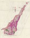
| Date: | 1961 |
|---|---|
| Description: | This map shows bays, lakes, and roads. Relief is shown by contours; depths are shown by isolines. Lake Michigan and Lake Winnebago are labeled. An explana... |
If you didn't find the material you searched for, our Library Reference Staff can help.
Call our reference desk at 608-264-6535 or email us at: