 Filter: Subject of peninsulas
Filter: Subject of indians of north america
Filter: Subject of peninsulas
Filter: Subject of indians of north america
| Date: | |
|---|---|
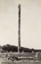
| Description: | The totem pole has a carved wooden bear clinging to the top. The totem pole was erected in 1927 in honor of the aboriginal inhabitants of Wisconsin. Potawa... |

| Date: | 1851 |
|---|---|
| Description: | This map shows townships, villages, Indian villages, railroads, roads, mills, prairies, swamps, and canals. An inset map shows a plat of the copper distric... |

| Date: | 1942 |
|---|---|
| Description: | This pictorial bird's-eye-view map shows the United States of America with parts of Canada and Mexico. Landscape, trade, industry, points of interest, peop... |

| Date: | 1946 |
|---|---|
| Description: | This map shows scenes from America's history with names of historical events superimposed on a map of the United States. |

| Date: | 2000 |
|---|---|
| Description: | This map shows national parks, county and state forests, Indian reservations, municipal land, private land, docks, boat access, camping, and points of inte... |

| Date: | 1630 |
|---|---|
| Description: | One of the few maps by Dutch cartographer Willem Blaeu depicting the Americas, this map shows regions, settlements, islands, mountains, forests, rivers, an... |

| Date: | 1772 |
|---|---|
| Description: | Map of the north west portion of America and Canada, as well as a small section of eastern Russia. Lakes, rivers, Native American land and the occasional ... |

| Date: | 1763 |
|---|---|
| Description: | Map showing the new British territories of East and West Florida following the Treaty of Paris at the end of the French and Indian War. It shows boundaries... |

| Date: | 1781 |
|---|---|
| Description: | Map of the Southeastern part of the British Colonies in North America, Gulf Coast and Caribbean. It illustrates the of the Spanish and English fleets, part... |
If you didn't find the material you searched for, our Library Reference Staff can help.
Call our reference desk at 608-264-6535 or email us at: