 Filter: Subject of peninsulas
Filter: Subject of service industries
Filter: Subject of peninsulas
Filter: Subject of service industries

| Date: | 1883 |
|---|---|
| Description: | Bird's-eye map of Superior, county seat of Douglas County, on the shores of Lake Superior, with insets of points of interest. |
| Date: | 1915 |
|---|---|
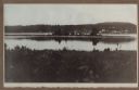
| Description: | Hen Island is reflected in the water of Fish Creek Bay in this view from Nelson Point in Peninsula State Park. The homes and businesses of Fish Creek are i... |
| Date: | 1915 |
|---|---|
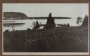
| Description: | View down hill towards a man fishing from the pier at Nelson Point in Peninsula State Park. Fish Creek is seen across the bay. Dr. Welcker's Casino is the ... |

| Date: | |
|---|---|
| Description: | Exterior of the menu for Paul's Cafe, with a bird's-eye view map of "Washburn's Natural Deep Water Land Locked Harbor," Chequamegon Bay, and the Apostle Is... |

| Date: | 1990 |
|---|---|
| Description: | This map shows the Minnesota Point, Wisconsin Point, Hog Island, Baker's Island, Connors Point, Blatnik Bridge, Superior Bay, Allouez Bay, the Nemadji Rive... |
If you didn't find the material you searched for, our Library Reference Staff can help.
Call our reference desk at 608-264-6535 or email us at: