 Filter: Subject of peninsulas
Filter: Subject of ships
Filter: Subject of peninsulas
Filter: Subject of ships

| Date: | 1883 |
|---|---|
| Description: | Bird's-eye map of Superior, county seat of Douglas County, on the shores of Lake Superior, with insets of points of interest. |

| Date: | 1930 |
|---|---|
| Description: | Aerial view from over Moonlight Bay, looking east across Bues Point to Spike Horn Bay and Cana Island. The Cana Island Lighthouse is seen as a ship passes ... |

| Date: | 1942 |
|---|---|
| Description: | This pictorial bird's-eye-view map shows the United States of America with parts of Canada and Mexico. Landscape, trade, industry, points of interest, peop... |

| Date: | 1946 |
|---|---|
| Description: | This map shows scenes from America's history with names of historical events superimposed on a map of the United States. |

| Date: | 1630 |
|---|---|
| Description: | One of the few maps by Dutch cartographer Willem Blaeu depicting the Americas, this map shows regions, settlements, islands, mountains, forests, rivers, an... |

| Date: | 1781 |
|---|---|
| Description: | Map of the Southeastern part of the British Colonies in North America, Gulf Coast and Caribbean. It illustrates the of the Spanish and English fleets, part... |
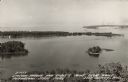
| Date: | 1940 |
|---|---|
| Description: | Text on front reads: "Sawyer Harbor and Cabot's Point from Tower, Potowatomi State Park, Door County, Wis." Elevated view across Sawyer Harbor towards Stur... |
If you didn't find the material you searched for, our Library Reference Staff can help.
Call our reference desk at 608-264-6535 or email us at: