 Filter: Subject of peninsulas

| Date: | 1930 |
|---|---|
| Description: | View from hill of Tripp Hall and Adams Hall on the University of Wisconsin-Madison campus. Lake Mendota and Picnic Point are in the background. |

| Date: | 04 1896 |
|---|---|
| Description: | View from Chi Psi porch on the University of Wisconsin-Madison campus. Picnic Point is stretching towards the right in the far background. There appears to... |
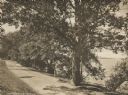
| Date: | 1916 |
|---|---|
| Description: | University Drive along Lake Mendota. Picnic Point can be seen across the lake. Caption reads: "University Drive." |

| Date: | 1929 |
|---|---|
| Description: | View from the tower of the Congregational Church towards Lake Mendota and the University of Wisconsin-Madison campus. Picnic Point is in the center backgro... |

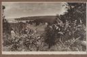
| Date: | 08 23 1964 |
|---|---|
| Description: | View from a rocky shoreline of a tree-lined peninsula in the distance. |
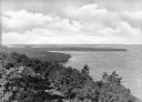
| Date: | |
|---|---|
| Description: | Elevated view of Shanty Bay at Peninsula State Park, established in 1910. |
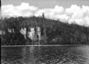
| Date: | |
|---|---|
| Description: | View across water towards Eagle Cliff at Peninsula State Park, established in 1910. |

| Date: | |
|---|---|
| Description: | People gather on the bank of Picnic Point, a tree-covered peninsula surrounded by water. A man and two children paddle a canoe along the shoreline. |

| Date: | 06 10 1954 |
|---|---|
| Description: | Members of the University of Wisconsin male crew row on Lake Mendota. Picnic Point is in the background. |
| Date: | 1920 |
|---|---|
| Description: | A well-dressed man identified as Uncle Rudolph Schenck takes in the view from a bluff overlooking the Fish Creek valley and harbor. There are houses and ou... |

| Date: | 1930 |
|---|---|
| Description: | Aerial view looking north across the wooded peninsula separating Europe Bay (top) from Newport Bay. This area is now part of Newport State Park. |

| Date: | 1930 |
|---|---|
| Description: | Aerial view of the northern tip of the Door Peninsula, looking north. Europe Lake is in the center, with Europe Bay to the right. Plum Island and Washingto... |

| Date: | 1930 |
|---|---|
| Description: | Aerial view looking northeast, with Rowley's Bay in the foreground. Europe Lake is to the left, with Europe Bay and Newport Bay separated by a narrow peni... |

| Date: | 1930 |
|---|---|
| Description: | Aerial view over northern Door County, looking northeast across Europe Lake and Europe Bay toward Plum and Washington Islands. Farm fields and orchards con... |

| Date: | 1930 |
|---|---|
| Description: | Aerial view from over Moonlight Bay, looking east across Bues Point to Spike Horn Bay and Cana Island. The Cana Island Lighthouse is seen as a ship passes ... |

| Date: | 1930 |
|---|---|
| Description: | Aerial view, looking north, across the beach and pier on Europe Bay to Europe Lake and beyond to Washington Island. The land south (to the right) of Europe... |

| Date: | 1899 |
|---|---|
| Description: | Map of Door County with inset photograph of Sturgeon Bay City. |

| Date: | 1915 |
|---|---|
| Description: | Elevated view, looking north, from the Hotz family compound near the bluff entrance to Fish Creek. Evergreens and bare birch trees stand in the foreground,... |
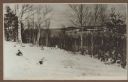
| Date: | 1915 |
|---|---|
| Description: | View looking north over Fish Creek Bay, with Hen Island and Peninsula State Park in the background. There is snow on the ground, and evergreens and bare bi... |

| Date: | 1915 |
|---|---|
| Description: | Elevated view over a heavily wooded area to Fish Creek Harbor and Hen Island, with Peninsula State Park in the background. |
If you didn't find the material you searched for, our Library Reference Staff can help.
Call our reference desk at 608-264-6535 or email us at: