 Filter: Subject of peninsulas
Filter: Year of 1800-1899
Filter: Subject of peninsulas
Filter: Year of 1800-1899

| Date: | 1883 |
|---|---|
| Description: | Bird's-eye map of Superior, county seat of Douglas County, on the shores of Lake Superior, with insets of points of interest. |
| Date: | 1888 |
|---|---|
| Description: | View of shoreline along Picnic Point on the University of Wisconsin-Madison campus showing the home of Professor William Daniels, head of the Chemistry Dep... |
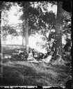
| Date: | 1877 |
|---|---|
| Description: | A group, probably at Picnic Point on Lake Mendota in Madison, posed under the trees. Picnic baskets are behind them. Mrs. Bashford is the person in Mrs. ... |
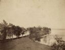
| Date: | 1887 |
|---|---|
| Description: | Picnic Point from University Drive. |

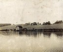
| Date: | 1888 |
|---|---|
| Description: | View of Picnic Point stretching out into Lake Mendota on the University of Wisconsin-Madison campus. |
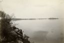
| Date: | 1888 |
|---|---|
| Description: | View of Picnic Point on the University of Wisconsin-Madison campus. The peninsula juts into Lake Mendota. The far shoreline can be seen in the distance. |

| Date: | 11 24 1898 |
|---|---|
| Description: | Elevated view from the top of Main Hall (later Bascom Hall) of Picnic Point on Lake Mendota from the University of Wisconsin-Madison campus. |

| Date: | 04 1896 |
|---|---|
| Description: | View from Chi Psi porch on the University of Wisconsin-Madison campus. Picnic Point is stretching towards the right in the far background. There appears to... |

| Date: | 1899 |
|---|---|
| Description: | Map of Door County with inset photograph of Sturgeon Bay City. |

| Date: | 07 1899 |
|---|---|
| Description: | Elevated view from hill of Picnic Point, located on the south shore of Lake Mendota. |

| Date: | 1851 |
|---|---|
| Description: | This map shows townships, villages, Indian villages, railroads, roads, mills, prairies, swamps, and canals. An inset map shows a plat of the copper distric... |
If you didn't find the material you searched for, our Library Reference Staff can help.
Call our reference desk at 608-264-6535 or email us at: