 Filter: Subject of picnicking
Filter: Subject of boats and boating
Filter: Subject of picnicking
Filter: Subject of boats and boating
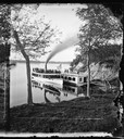
| Date: | 1879 |
|---|---|
| Description: | Norwegian Sunday School Picnic at Mendota steamboat landing. Small lake steamer "Mendota" could reach speeds of up to 18 mph. The barge "Uncle Sam" was 75f... |
| Date: | 1913 |
|---|---|
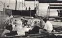
| Description: | Elevated view of wooden boats at Raspberry Island (or Devils Island) dock with picnickers on shore. The "Lizzie W' and Nelson Angus, A.G. Hull, Elsie Tough... |
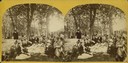
| Date: | 1877 |
|---|---|
| Description: | "The Grand Regatta, at Devil's Lake, June 21st & 22nd, 1877." A crowd sits on the ground about to commence lunch at Devil's Lake. |
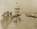
| Date: | 06 26 1909 |
|---|---|
| Description: | Two men paddle barrels with their hands and feet while a third tips over on Pewaukee Lake at the Waukesha Beach recreation area. Other people watch both f... |
| Date: | |
|---|---|
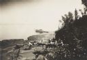
| Description: | Group having a picnic on the shore of an Apostle Island. There is a large sailboat behind the group. |
| Date: | 08 09 1947 |
|---|---|
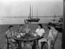
| Description: | A few of the children of Mendota Yacht Club members, seated on the terrace at the James Payton house, 409 N. Blair Street. Left to right: Mark Nesbit, Jimm... |

| Date: | 1930 |
|---|---|
| Description: | The back of the pictorial map titled Recreational Map of Glacier National Park, Montana: Waterton Lakes National Park, Alberta. 14 panels of text and photo... |

| Date: | |
|---|---|
| Description: | People gather on the bank of Picnic Point, a tree-covered peninsula surrounded by water. A man and two children paddle a canoe along the shoreline. |

| Date: | |
|---|---|
| Description: | View of Prochazka's picnic place on Rock River. The view features a small boat docked on the left near trees which crowd the shoreline. Caption reads: "Pro... |
| Date: | |
|---|---|
| Description: | We've at least been able to conserve something if it's only the idea of conserving for conservation's sake But the community interests ought to come fir... |
| Date: | 1912 |
|---|---|
| Description: | Picnic party on the rocks along the shore, among the Apostle Islands in Lake Superior. |

| Date: | 1960 |
|---|---|
| Description: | Chrome color postcard of the boat launch area. Text on back reads: "Forest County Veteran's Memorial Park located 3 miles from Crandon, WI on the south sho... |

| Date: | 1990 |
|---|---|
| Description: | This map shows various types of trails, boat landings, canoe areas, public beaches, picnic areas, campgrounds, golf courses, public tennis courts, and othe... |

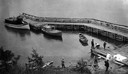
| Date: | 07 04 1905 |
|---|---|
| Description: | View down hill towards shoreline where a crowd fills a barge which has been fitted with benches, an awning, and American flags for an excursion on Buffalo ... |

| Date: | 1994 |
|---|---|
| Description: | This map shows historical sites, picnic grounds, public boat landings, canoe and motor boat trips, and resort locations. The left margin of the map include... |

| Date: | 2005 |
|---|---|
| Description: | This map shows dams and falls, areas of portage, canoe and kayak access, boat launches, parking, restrooms, picnic areas, dining, rapid water, parks, and b... |

| Date: | |
|---|---|
| Description: | View down slope towards several men posing at the shoreline while taking part in a lakeside gathering. Many of them are sitting on the grass or on boats dr... |
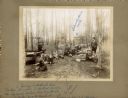
| Date: | |
|---|---|
| Description: | A group of men relax outdoors after fishing. Most are seated on the grass, while one man sits on and boat and another stands holding the day's catch. There... |

| Date: | 1949 |
|---|---|
| Description: | This multi-colored promotional map for recreational activities in the Hayward area includes a graphic of distances from Midwestern cities to Hayward, with ... |

| Date: | 1901 |
|---|---|
| Description: | Stereograph of a formation on the Wisconsin River called "The Ink Stand." On the shore a woman is sitting on a wooden bench, and behind her is a picnic bas... |
If you didn't find the material you searched for, our Library Reference Staff can help.
Call our reference desk at 608-264-6535 or email us at: