 Filter: Subject of piers
Filter: Subject of lumber trade
Filter: Subject of piers
Filter: Subject of lumber trade

| Date: | 1886 |
|---|---|
| Description: | Bird's-eye map of Washburn on Lake Superior. There is an inset of Washburn, Chequamagon and the Apostle Islands. |

| Date: | 1879 |
|---|---|
| Description: | Bird's-eye map of Two Rivers. |

| Date: | 1896 |
|---|---|
| Description: | Bird's-eye view of Washburn, with twenty vignettes around side, water in foreground with docks and lumber corral. Thirty-three locations identified in key ... |

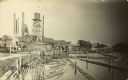
| Date: | 1870 |
|---|---|
| Description: | Stereograph of a view along the Fox River. A pier with pilings is along the right, with industrial buildings. |

| Date: | 1913 |
|---|---|
| Description: | Pawling & Harnischfeger 5-ton monorail hoist and track running over a body of water presumably to load a boat with lumber from a lumber yard. There is a ma... |

| Date: | 1913 |
|---|---|
| Description: | View from water of Pawling & Harnischfeger 5-ton monorail hoist with a lumber handling unit, possibly in Pensacola, Florida. The monorail track extends ove... |

| Date: | |
|---|---|
| Description: | View from water of Milwaukee Electric Crane & Manufacturing Company lumber crane in an unknown lumber yard. The cab is stamped "Milwaukee Electric Crane & ... |

| Date: | 1902 |
|---|---|
| Description: | Two panoramic bird's-eye views of the Paine Lumber Company, including the general plant, sawmill, and lumber yards. Heading at the top says: Home of Wiscon... |
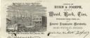
| Date: | |
|---|---|
| Description: | Letterhead of the Horn's Pier (Door County) office of Horn & Joseph, dealers in general merchandise, including "Wood, Bark, Ties, Telegraph Poles, Posts, &... |

| Date: | 1925 |
|---|---|
| Description: | Shows buildings, piers, winter and summer levels, and resort lands. Depths shown by isolines. Relief shown by contours. From the E.P. Sherry papers relatin... |
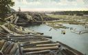
| Date: | 1910 |
|---|---|
| Description: | Colorized postcard of logs floating in river, looking east between falls and railroad bridge. In the upper right corner is a large number of logging pylons... |

| Date: | 06 1923 |
|---|---|
| Description: | Sanborn map of Ashland, which includes Chequamegon Bay. |
| Date: | 1910 |
|---|---|
| Description: | View from the Oconto River of the Holt Lumber Company. A man is standing on a log boom and guiding logs to the sawmill. Writing on the postcard reads: "Hol... |
If you didn't find the material you searched for, our Library Reference Staff can help.
Call our reference desk at 608-264-6535 or email us at:
