 Filter: Subject of public buildings
Filter: Subject of rivers
Filter: Subject of public buildings
Filter: Subject of rivers
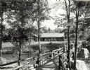
| Date: | 1940 |
|---|---|
| Description: | People on a rustic bridge over river at Copper Falls State Park. A long log building is in the background on the other side of the river. |

| Date: | 1890 |
|---|---|
| Description: | Bird's-eye map of Beloit with insets of Williams Engine Works, Eclipse Wind Engine Co., and John Foster & Co. Turtle Creek is in the lower section, and the... |
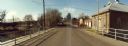
| Date: | 11 16 1989 |
|---|---|
| Description: | View from the Water Street Bridge over the Waupaca River toward the Waupaca Water Department. |
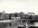
| Date: | 07 1940 |
|---|---|
| Description: | The bathing beach and bath house at Copper Falls State Park. Two swimmers are sitting and standing on a dock with a platform. |

| Date: | 07 1940 |
|---|---|
| Description: | Two boys and two girls swimming at the Bad River at Copper Falls State Park. One of the girls is diving off the dock that also has a platform. In the backg... |
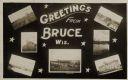
| Date: | 05 15 1909 |
|---|---|
| Description: | Photographic postcard of a poster promoting Bruce with seven photographs. The fairgrounds, Main Street, farm scene, Catholic Church, Chippewa River bridge,... |
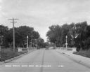
| Date: | 1930 |
|---|---|
| Description: | View down middle of road of car driving across a bridge over Sugar River. Another car is parked by the Wisconsin Power and Light Company. |

| Date: | 1896 |
|---|---|
| Description: | A map of Milwaukee County, Wisconsin that shows the township and range system, sections, towns, roads, railroads and rail stations, cities and villages, po... |

| Date: | 1874 |
|---|---|
| Description: | This map has relief shown by hachures and includes 7 inset maps of additions and subdivisions with varying scales. Also includes index of additions and loc... |

| Date: | 1910 |
|---|---|
| Description: | This map is a survey of Kenosha Harbor and shows local streets, public buildings, local businesses, and part of Lake Michigan. Included is text on sailing ... |

| Date: | 1893 |
|---|---|
| Description: | This map shows city wards, block numbers, parks, cemeteries, roads, railroads, selected buildings, and Lake Michigan. Also included are indexes to streets,... |

| Date: | 1905 |
|---|---|
| Description: | This blueprint map shows rivers, land parcels, and streets. It also highlights selected public and industrial buildings. |
If you didn't find the material you searched for, our Library Reference Staff can help.
Call our reference desk at 608-264-6535 or email us at: