 Filter: Subject of quarries and quarrying
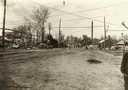
Filter: Subject of cities and towns
Filter: Subject of quarries and quarrying
Filter: Subject of cities and towns

| Date: | 05 14 1943 |
|---|---|
| Description: | Truck-mounted Catepillar engine/compressor parked at Albert W. Gallagher Quarry on Highway 51 near the airport. The photograph was taken for Nagle-Hart Tra... |
| Date: | |
|---|---|
| Description: | View of workers from the Montello Granite Company heading down the street to lunch after the noon whistle. |
| Date: | 02 16 1931 |
|---|---|
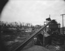
| Description: | Wisconsin Foundry & Machine Co. conveyor belt loading gravel into hopper which is filling a C.E. & P.A. Roth truck at their gravel pit, 1910 Roth Street ne... |

| Date: | 1908 |
|---|---|
| Description: | A view of the Montello granite quarry with Montello Lake in the background. The sign in the foreground reads, "J.T. Barrett Pays Highest Prices for Furs, M... |
| Date: | 1888 |
|---|---|
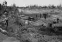
| Description: | Men working in Horlick's stone quarry. Teams of horses pull wagons. There is a steam pump at right. A man in a hat and coat, possibly William Horlick, stan... |

| Date: | 1883 |
|---|---|
| Description: | Bird's-eye view of Montello, county seat of Marquette County. The granite quarry, woolen mill, and planing mill are clearly identified. A steamboat on Buf... |
| Date: | |
|---|---|
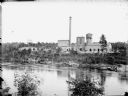
| Description: | View across river of York Iron Works. On the hill are the boardinghouse and dance hall. Just below the boardinghouse there appears to be a quarry. |

| Date: | 1917 |
|---|---|
| Description: | A geological survey map that shows the sedimentary and igneous deposits in southeastern Wisconsin and south central Wisconsin, as well as the limits of gla... |

| Date: | 1915 |
|---|---|
| Description: | This map of Door County, Wisconsin, from the early 20th century shows roads, schools, churches, creameries and cheese factories, orchards, docks, quarries,... |

| Date: | 1889 |
|---|---|
| Description: | This 1889 map of Douglas County, Wisconsin, shows the township and range grid, towns, sections, cities and villages, roads, existing and proposed railroads... |

| Date: | 1892 |
|---|---|
| Description: | This 1892 map of Douglas County, Wisconsin, shows the township and range grid, towns, sections, cities and villages, roads, railroads, trails, lakes and st... |

| Date: | 1862 |
|---|---|
| Description: | This map shows townships and sections, landownership and acreages, roads, railroads, cemeteries, churches, schools, mills, and stone quarries. "Engraved, p... |

| Date: | 1887 |
|---|---|
| Description: | This late 19th century map shows the lake region around Oconomowoc in Waukesha County and eastern Jefferson County, Wisconsin. Cities and villages, roads, ... |

| Date: | 1878 |
|---|---|
| Description: | This 1878 map of Wood County, Wisconsin, shows the township and range grid, towns, sections, cities, villages and post offices, landownership, roads, railr... |

| Date: | |
|---|---|
| Description: | Photographic postcard view of a quarry with water at the bottom. Caption reads: "A Pit at the 'Klondike' Granite Quarry, Berlin, Wis." |
| Date: | 1904 |
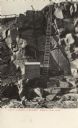
|---|---|
| Description: | Photographic postcard view of the bottom of the quarry, with a ladder from the bottom of the pit to top. There is a shed at the foot of the ladder. Caption... |
| Date: | |
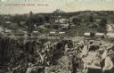
|---|---|
| Description: | Partially colorized view looking down at a quarry. On the other side of the quarry is the town of Berlin, with dwellings and commercial buildings. Caption ... |

| Date: | 1902 |
|---|---|
| Description: | This map is watercolor and pen on paper and relief shown by contours. The map reads: "Contour interval 10 feet." Shown on the map are geological features a... |
If you didn't find the material you searched for, our Library Reference Staff can help.
Call our reference desk at 608-264-6535 or email us at:

