 Filter: Subject of quarries and quarrying
Filter: Subject of dwellings
Filter: Subject of quarries and quarrying
Filter: Subject of dwellings

| Date: | 10 21 1931 |
|---|---|
| Description: | Elevated view of a colony of squatters in Sunset Point (Hoyt Park, Quarry Park), former quarry site. Home of John & Lottie Corcoran from 1924-1994. |

| Date: | 1883 |
|---|---|
| Description: | Bird's-eye view of Montello, county seat of Marquette County. The granite quarry, woolen mill, and planing mill are clearly identified. A steamboat on Buf... |
| Date: | |
|---|---|
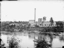
| Description: | View across river of York Iron Works. On the hill are the boardinghouse and dance hall. Just below the boardinghouse there appears to be a quarry. |

| Date: | 1867 |
|---|---|
| Description: | This 1867 manuscript map by Increase Lapham shows the topography and geology of the Blue Mounds region in the Town of Brigham in Iowa County and the towns ... |
| Date: | |
|---|---|
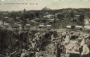
| Description: | Partially colorized view looking down at a quarry. On the other side of the quarry is the town of Berlin, with dwellings and commercial buildings. Caption ... |

| Date: | 1910 |
|---|---|
| Description: | Hand-colored lantern slide of the Indiana Monument at the Andersonville National Cemetery. The monument was made of Montello granite at a cost of $10,000 i... |

| Date: | 1910 |
|---|---|
| Description: | View over quarry towards two men in suits sitting at the top edge of the cut face of the granite quarry. In the background is a house at the top of the hil... |

| Date: | 06 12 1929 |
|---|---|
| Description: | This manuscript blueprint shows buildings with the names of their owners, tabernacle, location "where Strang found plates" and "house where Strang died," a... |

| Date: | 1864 |
|---|---|
| Description: | This map shows locations of quarries, sink holes, creeks, springs, rivers, houses, forts, and roads. |
If you didn't find the material you searched for, our Library Reference Staff can help.
Call our reference desk at 608-264-6535 or email us at:

