 Filter: Subject of quarries and quarrying
Filter: Subject of landforms
Filter: Subject of quarries and quarrying
Filter: Subject of landforms
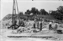
| Date: | 06 13 1913 |
|---|---|
| Description: | Workmen and machinery at the quarry on Blackhawk Bluff. The gravel was used in construction of the power dam. |
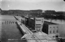
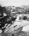
| Date: | 08 19 1915 |
|---|---|
| Description: | Elevated view of the completed power house and dam, looking east at the north, or upstream, side of the structure. On the far shore, the site of the gravel... |
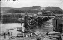
| Date: | 07 16 1912 |
|---|---|
| Description: | Workers posing inside the coffer dam. The narrow gauge railroad is behind them. One of the pile drivers is in the background. A bare area on the bluff in t... |
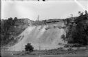
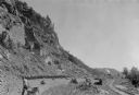
| Date: | 06 13 1913 |
|---|---|
| Description: | A view, from the west, of the quarry on Blackhawk Bluff. Gravel from the quarry was used in concrete for the construction of the power plant and dam. |

| Date: | 1867 |
|---|---|
| Description: | This 1867 manuscript map by Increase Lapham shows the topography and geology of the Blue Mounds region in the Town of Brigham in Iowa County and the towns ... |

| Date: | |
|---|---|
| Description: | Elevated view of a man operating a TD-30 Crawler Tractor. |
| Date: | 07 1936 |
|---|---|
| Description: | A worker is pulling a wheelbarrow behind him while walking alongside a narrow gauge railroad track at the south end of the East Bluff near Devil's Lake. Em... |
| Date: | 1977 |
|---|---|
| Description: | Elevated view across a granite quarry looking west, with Buffalo Lake in the background. Buildings of the town are between the quarry and the lake, and a p... |
If you didn't find the material you searched for, our Library Reference Staff can help.
Call our reference desk at 608-264-6535 or email us at: