 Filter: Subject of railroad bridges
Filter: Subject of architecture
Filter: Subject of intellectual life
Filter: Subject of railroad bridges
Filter: Subject of architecture
Filter: Subject of intellectual life

| Date: | 1896 |
|---|---|
| Description: | Bird's-eye map of Darlington. Area bordered by Washington and North Streets, upper left hand corner, the fairgrounds, upper right corner, River Street, bot... |

| Date: | 1893 |
|---|---|
| Description: | Bird's-eye map of Jefferson, looking north. Crayfish River at left and center, Rock River from upper center to bottom center, joins at left of center; thir... |

| Date: | 1883 |
|---|---|
| Description: | Bird's-eye map of Prairie du Sac, Wisconsin with an inset of Clifton. |

| Date: | 1891 |
|---|---|
| Description: | Bird's-eye map of Stevens Point, looking east, with an inset of the Water Works. Wisconsin River in foreground with fifty-three business locations identifi... |

| Date: | 1879 |
|---|---|
| Description: | Bird's-eye map of Two Rivers. |

| Date: | 09 03 1912 |
|---|---|
| Description: | An experimental reaper(?) in a factory yard. There is a Russian name on the Reaper, and the front is set up on saw-horses. Men are working near a brick fac... |

| Date: | 1889 |
|---|---|
| Description: | Chicago & North Western Railway viaduct on the line along the Milwaukee River. The viaduct has two arched passages, and stones and rocks lining the path f... |
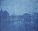
| Date: | 1893 |
|---|---|
| Description: | A cyanotype view of the World's Columbian Exposition grounds from near the North Loop elevated railway station, showing the glass dome of the Horticulture ... |

| Date: | |
|---|---|
| Description: | Bird's-eye view of the north branch extension canal on the Susquehanna river, surrounded by smaller renderings of structures of interest around the town in... |
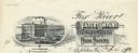
| Date: | |
|---|---|
| Description: | Letterhead of the Fox River Paper Company of Appleton, Wisconsin, with a three-quarter view of the company building and a hanging roll of paper that incorp... |
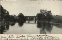
| Date: | 1907 |
|---|---|
| Description: | View over water towards a railroad bridge over a river. Trees and shrubs are along the banks of the river. There are buildings in the distance behind the b... |

| Date: | 09 04 1885 |
|---|---|
| Description: | Exterior and interior bill of fare from The Chequamegon, with views on the back of rock formations, waterfalls, a spot illustration of a train going over a... |

| Date: | 08 11 1950 |
|---|---|
| Description: | Aerial view of paper mill. There are bridges across the river, including a railroad bridge on the far right. |

| Date: | |
|---|---|
| Description: | Elevated panoramic view of the city of Madison, with the Wisconsin State Capitol and Lake Monona on the far left, and Picnic Point and Lake Mendota on the ... |

| Date: | 09 14 1938 |
|---|---|
| Description: | Aerial, panoramic view towards the Chickamauga Dam. |
If you didn't find the material you searched for, our Library Reference Staff can help.
Call our reference desk at 608-264-6535 or email us at: