 Filter: Subject of railroad bridges
Filter: Subject of bridges
Filter: Subject of rivers
Filter: Subject of railroad bridges
Filter: Subject of bridges
Filter: Subject of rivers
| Date: | |
|---|---|
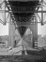
| Description: | Interior of railroad bridge, with walkway below. There is a man standing on the left at the railing of the walkway. |
| Date: | |
|---|---|
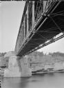
| Description: | View of the river and the underside of a railroad bridge at Kilbourn. There is a building in the background on the right just above the cliffs along the ri... |

| Date: | 1896 |
|---|---|
| Description: | Bird's-eye map of Darlington. Area bordered by Washington and North Streets, upper left hand corner, the fairgrounds, upper right corner, River Street, bot... |

| Date: | 1877 |
|---|---|
| Description: | Bird's-eye map of Janesville on the Rock River. |

| Date: | 1893 |
|---|---|
| Description: | Bird's-eye map of Jefferson, looking north. Crayfish River at left and center, Rock River from upper center to bottom center, joins at left of center; thir... |

| Date: | 1891 |
|---|---|
| Description: | Bird's-eye map of Stevens Point, looking east, with an inset of the Water Works. Wisconsin River in foreground with fifty-three business locations identifi... |

| Date: | 1879 |
|---|---|
| Description: | Bird's-eye map of Two Rivers. |
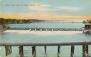
| Date: | |
|---|---|
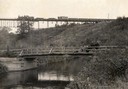
| Description: | A freight train makes its way across a bridge over a dam on the Black River. |
| Date: | 1910 |
|---|---|
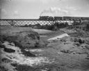
| Description: | View from shoreline of a railroad train crossing a bridge over the famous White River near Ashland. In the foreground is an open automobile crossing the ri... |
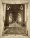
| Date: | 1877 |
|---|---|
| Description: | View of the lower level of the Chicago, Milwaukee, and St. Paul railroad bridge at the Wisconsin Dells that would have been used by pedestrians and horse-d... |

| Date: | 1930 |
|---|---|
| Description: | Aerial view of the city and the river. |
| Date: | 1905 |
|---|---|
| Description: | Elevated view of John Street Bridge. Caption reads: "John Street Bridge, Appleton, Wis. Largest stone arch bridge in Wisconsin." A railroad bridge runs acr... |
| Date: | 1906 |
|---|---|
| Description: | Elevated view of the bridge, which is intersected by a railroad bridge. Caption reads: "John St. Bridge, Appleton, Wis. Largest stone arch bridge in Wiscon... |
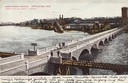
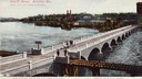
| Date: | 1905 |
|---|---|
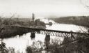
| Description: | View of the Rock River with the Northwestern Railroad Bridge in the foreground and Beloit in the background. Caption reads: "Bird's-Eye View of River, Belo... |
| Date: | |
|---|---|
| Description: | Elevated view of the river with multiple bridges across it, including at least two railroad bridges. There is a factory on the left bank with smokestacks, ... |
| Date: | 1905 |
|---|---|
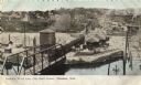
| Description: | Elevated view of the railroad station looking west. A bridge over the river is in the foreground, and a large water tower is across the railroad tracks on ... |
| Date: | 1904 |
|---|---|
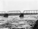
| Description: | Logs floating down the river beneath the bridge on the Chippewa River. On the far shoreline are billboards. One advertises for "J.R. Sharp Hardware." Men a... |

| Date: | 1950 |
|---|---|
| Description: | An aerial view of town, showing a major industrial area. |

| Date: | 1859 |
|---|---|
| Description: | Map featuring various views of buildings and scenes from Sauk County. |
| Date: | |
|---|---|
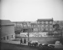
| Description: | Billboards with advertising for the "Georgia Up-To-Date Minstrels" at the Opera House on Saturday, April 7. Bridge visible to the left. The J.J. McGillivra... |
If you didn't find the material you searched for, our Library Reference Staff can help.
Call our reference desk at 608-264-6535 or email us at: