 Filter: Subject of railroad bridges
Filter: Subject of land
Filter: Subject of cities and towns
Filter: Subject of railroad bridges
Filter: Subject of land
Filter: Subject of cities and towns
| Date: | 1884 |
|---|---|
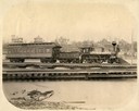
| Description: | View across water of a Milwaukee, Lake Shore, and Western Railroad locomotive (No #33) pulling a pay car across a trestle over the Fox River. Several large... |

| Date: | 07 10 1949 |
|---|---|
| Description: | Aerial view of Minocqua showing the surrounding lakes. |
| Date: | 03 19 1919 |
|---|---|
| Description: | Small steam engine hauling empty cars over a bridge along a narrow gauge railroad track. Houses in a residential neighborhood are in the background. The tr... |

| Date: | 1896 |
|---|---|
| Description: | Bird's-eye map of Darlington. Area bordered by Washington and North Streets, upper left hand corner, the fairgrounds, upper right corner, River Street, bot... |

| Date: | 1877 |
|---|---|
| Description: | Bird's-eye map of Janesville on the Rock River. |

| Date: | 1893 |
|---|---|
| Description: | Bird's-eye map of Jefferson, looking north. Crayfish River at left and center, Rock River from upper center to bottom center, joins at left of center; thir... |

| Date: | 1870 |
|---|---|
| Description: | Bird's-eye map of Kilbourn City, now known as Wisconsin Dells. Kilbourn City was platted in the 1850s and received a boost when the La Crosse and Milwaukee... |

| Date: | 1870 |
|---|---|
| Description: | Bird's-eye view of the city of Manitowoc with a population of 5,168 inhabitants as it appears in 1870, the year the village was granted a city charter by t... |

| Date: | 1883 |
|---|---|
| Description: | Bird's-eye map of Prairie du Sac, Wisconsin with an inset of Clifton. |

| Date: | 1883 |
|---|---|
| Description: | Bird's-eye map of Sauk City. |

| Date: | 1891 |
|---|---|
| Description: | Bird's-eye map of Stevens Point, looking east, with an inset of the Water Works. Wisconsin River in foreground with fifty-three business locations identifi... |

| Date: | 1879 |
|---|---|
| Description: | Bird's-eye map of Two Rivers. |
| Date: | 09 29 1963 |
|---|---|
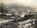
| Description: | The Menasha Woodenware plant and water tower on Doty Island from across the Fox River canal, with a small railroad dolly in the foreground. |
| Date: | 09 29 1963 |
|---|---|
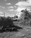
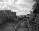
| Description: | View down railroad tracks towards the railroad bridge, with industrial plants on Doty Island. |
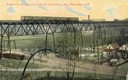
| Date: | 1911 |
|---|---|
| Description: | Elevated view across valley toward a streetcar viaduct on the Waukesha Interurban Line, near Milwaukee. Caption reads: "Street Car Bridge on Waukesha Inter... |
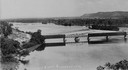
| Date: | 1933 |
|---|---|
| Description: | Elevated view of a covered railroad bridge over a calm body of water, with bluffs in the background. |
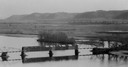
| Date: | |
|---|---|
| Description: | Elevated view of railroad bridge over the river. Part of the bridge is covered. Bluffs are in the background. |

| Date: | 1930 |
|---|---|
| Description: | Aerial view of Carson Park, Half Moon Lake and part of the West Side in the foreground. The municipal bath house is on the lake shore in the foreground. A ... |
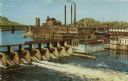
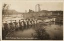
| Date: | |
|---|---|
| Description: | Elevated view of the dam and the power plant. A railroad bridge is in the upper left. Three smokestacks are in the background. |
| Date: | 1930 |
|---|---|
| Description: | Elevated view of the dam and the mill, with some trees in the foreground. A railroad bridge is in the background on the left, and a rail cart or truck is d... |
If you didn't find the material you searched for, our Library Reference Staff can help.
Call our reference desk at 608-264-6535 or email us at: