 Filter: Subject of recreation areas
Filter: Subject of maps
Filter: Subject of recreation areas
Filter: Subject of maps

| Date: | 1870 |
|---|---|
| Description: | Bird's-eye view of the city of Manitowoc with a population of 5,168 inhabitants as it appears in 1870, the year the village was granted a city charter by t... |

| Date: | |
|---|---|
| Description: | Poster advertising the Elmside lots for summer homes by Lake Monona. |

| Date: | 1904 |
|---|---|
| Description: | A map showing the design for a park fronting on Lake Monona Bay. (Now called Brittingham Park) taken from between pages 44 & 45 of the 1905 Madison Park a... |
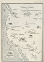
| Date: | 06 1930 |
|---|---|
| Description: | A map of the western states showing "public playlands," mostly national parks. |
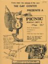
| Date: | 1979 |
|---|---|
| Description: | Poster for picnic presented by the Gay Center at Vilas Park. Includes an image of a fox and telephone. |

| Date: | 01 08 1965 |
|---|---|
| Description: | The new master plan for the Henry Vilas park and zoo is reviewed by Atty. George F. Lange, president of the Henry Vilas Zoological Society, Inc. and Mrs. G... |

| Date: | 04 13 1965 |
|---|---|
| Description: | Al Schurch, Mr. Horeb, captain of the Zor Shrine Camel patrol, presents a donation to Paul Hartung, president of the Madison Junior Chamber of Commerce for... |

| Date: | 1941 |
|---|---|
| Description: | This map highlights the fishing district and shows labeled rivers, lakes, cities, county boundaries and points of interest. The map includes a list of trai... |

| Date: | 1889 |
|---|---|
| Description: | This map lists township and section numbers outside municipality, housing additions and subdivisions and plat owners outside municipality, the Black River,... |

| Date: | 1966 |
|---|---|
| Description: | This blue line print shows existing and proposed streets, docks, company-owned land, railroads and railroad yards, parks, and municipal airport. |

| Date: | 11 1964 |
|---|---|
| Description: | Fold-out map of the zoo inside a publication titled: "Henry Vilas Park Zoo: An Instructive Book on the Origin and Habits of Animals." Includes Lake Wingra,... |
If you didn't find the material you searched for, our Library Reference Staff can help.
Call our reference desk at 608-264-6535 or email us at: