 Filter: Subject of recreation areas
Filter: Subject of rivers
Filter: Subject of recreation areas
Filter: Subject of rivers
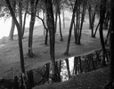
| Date: | 09 22 1962 |
|---|---|
| Description: | Elevated view of trees and pool of water near the Wisconsin River in Pauquette Park. |
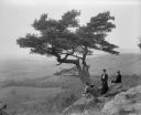
| Date: | 1902 |
|---|---|
| Description: | Two women and a man pose atop Gibraltar Rock in Richmond Memorial Park, which was dedicated by Jens Jensen and the Wisconsin Friends in 1927 in order to co... |

| Date: | 2007 |
|---|---|
| Description: | This map of Cedarbug is a bird's-eye map with 8 inset views and an index. The map is a print out of the original map dated 1892 held at the Cedarburg Cultu... |

| Date: | 1891 |
|---|---|
| Description: | Bird's-eye view of Eau Claire. |

| Date: | 04 18 1935 |
|---|---|
| Description: | Miss Pyre standing next to a Ford V-8 coupe near a bridge at Tenney Park. A building with a tower is in the background, perhaps the Hausmann Brewing Compan... |
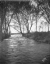
| Date: | 10 13 1927 |
|---|---|
| Description: | Scenic view of outlet of Lake Mendota near Tenney Park and Yahara River. |
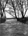
| Date: | 10 15 1927 |
|---|---|
| Description: | Scenic view of outlet of Lake Mendota near Tenney Park and Yahara River. |

| Date: | 1927 |
|---|---|
| Description: | Color map, hand-drawn with comic figures engaged in various activities throughout map. Bordered by the river on the left and Lake Michigan on the right, in... |

| Date: | 1892 |
|---|---|
| Description: | Bird's-eye view of Chicago, with ships in the Lake Michigan harbor. |
| Date: | 1930 |
|---|---|
| Description: | Sunbathers relax on the piers at the swimming park on the Milwaukee River. |
| Date: | 1885 |
|---|---|
| Description: | Chippewa Falls with a park and river in the foreground. |

| Date: | 1930 |
|---|---|
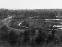
| Description: | Aerial view of Carson Park, Half Moon Lake and part of the West Side in the foreground. The municipal bath house is on the lake shore in the foreground. A ... |
| Date: | |
|---|---|
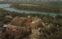
| Description: | Aerial view of the hospital along the banks of a river, with a bridge on the far left. Beyond the river is a baseball park. On the back of the card is writ... |
| Date: | |
|---|---|
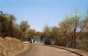
| Description: | View down a road in the park, leading to a river and a bridge. |
| Date: | |
|---|---|
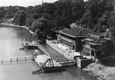
| Description: | The Spillway on Lake Mendota (Tenney Park) and the Yahara River. |

| Date: | 1930 |
|---|---|
| Description: | Aerial view of Tenney Park, including the lagoon, residences surrounding the park, and the shoreline of Lake Mendota on bottom left. |

| Date: | 1907 |
|---|---|
| Description: | The Yahara River Parkway, with the old Lapham School at 1436 East Dayton Street at North Thornton visible on the righthand side. |

| Date: | 07 05 1975 |
|---|---|
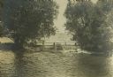
| Description: | The Tenney Park Bridge over the Yahara River. |
| Date: | 1870 |
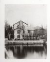
|---|---|
| Description: | View across water towards the Habheger's Bowling Park at the North Fourth Street bridge. A group of people are standing on the bridge. |
If you didn't find the material you searched for, our Library Reference Staff can help.
Call our reference desk at 608-264-6535 or email us at:
