Filter: Subject of resorts
Filter: Creator Name of Unknown
Filter: Subject of lakes
Filter: Subject of resorts
Filter: Creator Name of Unknown
Filter: Subject of lakes

| Date: | 1870 |
|---|---|
| Description: | Bird's-eye map of Madison. The Lakeside House resort is in the foreground, which burned in 1877, in what is now Olin Park. |
| Date: | 1890 |
|---|---|
| Description: | Old Mission Inn and boats on shoreline of Lake Superior on Madeline Island. The Old Mission Inn had numerous modifications over the years. It was razed in... |
| Date: | |
|---|---|
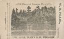
| Description: | View of the Cliff House on the lake, with pine trees surrounding the property, and a cliff behind the building. |
| Date: | 1955 |
|---|---|
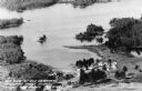
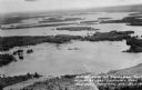
| Description: | Aerial view of Treeland Pines resort on Lake Chippewa. Caption reads: "Air View of Bob Cammack's Treeland Pines Resort; Lake Chippewa, Hayward, Wis." |
| Date: | 1955 |
|---|---|
| Description: | Aerial view of Treeland Pines Resort on Lake Chippewa. Caption reads: "Aerial View of Treeland Pines Resort on Lake Chippewa (The Flowage), Hayward, Wis." |
| Date: | |
|---|---|
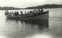
| Description: | Large group of guests at Warner's Resort, Plum Lake, enjoying a boat ride. |
| Date: | 1867 |
|---|---|
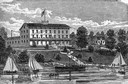
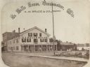
| Description: | A summer resort, situated on the banks of Fowler and La Belle Lakes, in the village of Oconomowoc, thirty miles from Milwaukee on the St. Paul R.R. Men sta... |
| Date: | |
|---|---|
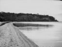
| Description: | A view of the beach at Smokey Point Resort, on Big Leech Lake. |

| Date: | 1930 |
|---|---|
| Description: | This manuscript map, likely drawn in the 1930s, shows Fox Lake, in Dodge County, Wisconsin, and the roads and resorts in the vicinity. |

| Date: | |
|---|---|
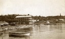
| Description: | Colorized postcard view over water towards boats and boaters at a resort. In the background are people and boats near a pier. The resort is among trees on ... |

| Date: | |
|---|---|
| Description: | Colorized photographic postcard view of a lawn with stone terraces and birch trees leading down to a lake on the left. There is a cabin in the background n... |
| Date: | 1910 |
|---|---|
| Description: | Photographic postcard view from hill through trees and over a bridge toward the Crystal Lake Resort on the opposite shoreline. There are two women wearing ... |
| Date: | 1910 |
|---|---|
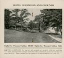
| Description: | The centerfold of a promotional brochure features a photograph of the Hotel Glenwood and a description of the springs on the grounds. The hotel, with large... |

| Date: | 1910 |
|---|---|
| Description: | This map shows shoreline lot numbers and acreages, the Wisconsin River, and the Michigan and Wisconsin state line. Manuscript annotations relating to topon... |

| Date: | 1952 |
|---|---|
| Description: | This map shows roads, foot and canoe trails, railroads, resorts, lookout towers, camps, national and state forests, Indian reservation, and types of fish i... |

| Date: | 1969 |
|---|---|
| Description: | This map shows ski areas, resorts, camps, special areas, airports, and roads. The map covers Vilas and Oneida counties and parts of Iron, Price, Lincoln, L... |

| Date: | |
|---|---|
| Description: | View across Lake Monona towards the Tonyawatha Spring Hotel. The hotel, on the east shore of the lake, is located in Blooming Grove Township, just outside ... |

| Date: | 1900 |
|---|---|
| Description: | This map shows logging roads, railroads with spur lines, trails, rapids, lumber camps, Indian villages, summer resort, lakes, rivers, and ponds. |

| Date: | 1975 |
|---|---|
| Description: | This map shows nature trails, public attractions, public hunting and fishing grounds, dams, waysides, lakes, highways, and roads. The upper right corner in... |
If you didn't find the material you searched for, our Library Reference Staff can help.
Call our reference desk at 608-264-6535 or email us at: