Filter: Subject of resorts
Filter: Reproduction Rights of For Sale
Filter: Subject of advertising
Filter: Subject of resorts
Filter: Reproduction Rights of For Sale
Filter: Subject of advertising
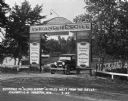
| Date: | 07 1927 |
|---|---|
| Description: | Car parked underneath the entrance gate to the Island Resort at the Wisconsin Dells, 25 miles from the Dells on Highway 12-16 near Mauston. Entrance gate a... |

| Date: | 1886 |
|---|---|
| Description: | Bird's-eye map of Baraboo with inset of Devil's Lake, the south and east sides of the commercial square, the First National Bank, and the Warren House hote... |
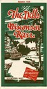
| Date: | 1928 |
|---|---|
| Description: | "The Dells," a brochure issued by the Chicago, Milwaukee & St. Paul and Pacific Railroad to advertise the Wisconsin Dells, a destination only five hours fr... |
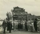
| Date: | |
|---|---|
| Description: | Group of resort and hotel owners gathered in front of a Wisconsin tourism sign that reads: "Relax In Wisconsin." There is a building in the background. |

| Date: | 1910 |
|---|---|
| Description: | Cover of brochure for Old Timer's Resort (formerly Burke's Resort). |
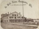
| Date: | 1867 |
|---|---|
| Description: | A summer resort, situated on the banks of Fowler and La Belle Lakes, in the village of Oconomowoc, thirty miles from Milwaukee on the St. Paul R.R. Men sta... |
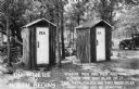
| Date: | 1935 |
|---|---|
| Description: | Two outhouses in the woods made of vertical logs. On their doors, one says "PA" and the other says "MA". There is an automobile with two small boys sitting... |

| Date: | 1991 |
|---|---|
| Description: | This 1991 map of Burnett County, Wisconsin, shows Governor Knowles State Forest, wildlife areas, public hunting grounds, and other outdoor recreation facil... |

| Date: | |
|---|---|
| Description: | An advertisement for El Nina Rancho, "a bit of old Mexico transplanted in beautiful Waushara County." The ad includes a photograph of people in riding clot... |
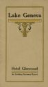
| Date: | 1910 |
|---|---|
| Description: | The cover of a promotional pamphlet for Hotel Glenwood and Glenwood Springs at the western end of Geneva Lake. |

| Date: | 2006 |
|---|---|
| Description: | This map includes indexed advertisements and map of the Lac du Flambeau region on back. The map is broken into 9 zones, each marked with state and club tra... |

| Date: | 1961 |
|---|---|
| Description: | This map shows the lake, clubs, resorts, motels, school house, public approaches, and public parks. The back of map includes advertisements and text. |

| Date: | 1935 |
|---|---|
| Description: | This blue lined map shows the major roads and cities of Wisconsin. The map includes an index, hotel and cafe advertisements, as well as advertisements for ... |

| Date: | 1935 |
|---|---|
| Description: | This blue lined map ("compliments of Black Eagle Oil Company") shows the major roads and cities of Wisconsin. The map includes an index, hotel and cafe adv... |

| Date: | 1975 |
|---|---|
| Description: | This map shows nature trails, public attractions, public hunting and fishing grounds, dams, waysides, lakes, highways, and roads. The upper right corner in... |

| Date: | 1943 |
|---|---|
| Description: | This map shows roads, trails, taverns, schools, golf, gas stations, campsites, resorts, and towers. The lower left of the map includes a legend. The map co... |

| Date: | 1991 |
|---|---|
| Description: | This map shows public access, fish crib locations, resorts, and other local businesses as well as advertisements for local attractions and a resort index. ... |

| Date: | 1922 |
|---|---|
| Description: | This map shows in red the NorthWestern Railway Line routes running from Chicago, Illinois to northern Wisconsin. The map includes cities and towns, lakes, ... |
| Date: | 1950 |
|---|---|
| Description: | Text on front reads: "Agnes and Steve's Resort on Wheeler Flowage, Townsend, Wis." A bar with a sign on the roof that reads: "Agnes and Steve's Bar". Signs... |
If you didn't find the material you searched for, our Library Reference Staff can help.
Call our reference desk at 608-264-6535 or email us at: