 Filter: Subject of resorts
Filter: Reproduction Rights of For Sale
Filter: Subject of marshes
Filter: Subject of resorts
Filter: Reproduction Rights of For Sale
Filter: Subject of marshes

| Date: | 1974 |
|---|---|
| Description: | This 1968 map identifies resorts in the Lac du Flambeau Indian Reservation region of Wisconsin, covering parts of Iron, Vilas, Oneida, and Price counties. ... |

| Date: | 1930 |
|---|---|
| Description: | Original map made with watercolor and inkwash. Includes a legend of buildings, roads, natural features and other details of the lodge. Inset at bottom has ... |

| Date: | 1951 |
|---|---|
| Description: | This map shows land use, dwellings, resorts, camps, marshes, springs, dams, lake bottom composition, and access. The map includes a fish species table, geo... |
| Date: | |
|---|---|
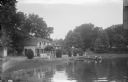
| Description: | View across water towards a section of Sandy Beach Resort. There are people on the lawn on the left next to buildings. Two women are talking on a porch in ... |
| Date: | |
|---|---|
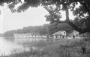
| Description: | View from shoreline of Sandy Beach Resort. The building near the pier on the left has a sign on the roof for the resort. Along the shoreline are buildings,... |
If you didn't find the material you searched for, our Library Reference Staff can help.
Call our reference desk at 608-264-6535 or email us at: