 Filter: Subject of resorts
Filter: Subject of camping
Filter: Subject of resorts
Filter: Subject of camping
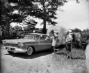
| Date: | 06 1959 |
|---|---|
| Description: | Two men with cameras around their necks stand near a couple in a Plymouth pulling an airstream camper through a gate. The sign on the gate in the backgroun... |
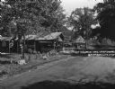
| Date: | 1925 |
|---|---|
| Description: | An information station advertising: free camping, with hot sandwiches and coffee, and tents and cots for sale. On a utility line pole, there are signs for ... |

| Date: | 1931 |
|---|---|
| Description: | Men and women, some in bathing suits, pose in front of the Gallop Inn Resort restaurant. |

| Date: | 1958 |
|---|---|
| Description: | Includes images of Flambeau River State Forest and a description of, canoeing and recreational activities in, and general park and forest information about... |
| Date: | 1929 |
|---|---|
| Description: | A man, woman, and child pose by a car near a tourist camping stop. |

| Date: | |
|---|---|
| Description: | View of five men standing outside holding full lines of fish they caught at Nature Lovers Paradise resort located on Jackson Lake. In the background are tw... |
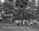
| Date: | 1930 |
|---|---|
| Description: | A group of men and women pose on the lawn outside their cottages at the Little Mountain Resort. |
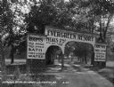
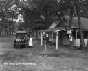
| Date: | 1929 |
|---|---|
| Description: | The entrance way to the Evergreen Resort. The sign advertises rooms, hot and cold water baths, meals, camp sites, and tourist kitchens. Caption reads: "Eve... |

| Date: | 1926 |
|---|---|
| Description: | This brochure was intended for tourists and shows resorts, lakes and railroads in northwestern Wisconsin and part of Michigan’s upper peninsula. Also inclu... |

| Date: | 1930 |
|---|---|
| Description: | This map shows roads and lakes and includes an inset illustration of Manitowish Waters Fish Hatchery. The back of the map includes a resorts directory, tex... |

| Date: | 1943 |
|---|---|
| Description: | This map shows roads, trails, taverns, schools, golf, gas stations, campsites, resorts, and towers. The lower left of the map includes a legend. The map co... |

| Date: | 1991 |
|---|---|
| Description: | This map shows public access, fish crib locations, resorts, and other local businesses as well as advertisements for local attractions and a resort index. ... |

| Date: | 1921 |
|---|---|
| Description: | This map shows in red the NorthWestern Railway Line routes running from Chicago, Illinois to northern Wisconsin and Michigan. The map includes cities and t... |

| Date: | 1922 |
|---|---|
| Description: | This map shows in red the NorthWestern Railway Line routes running from Chicago, Illinois to northern Wisconsin. The map includes cities and towns, lakes, ... |

| Date: | 1976 |
|---|---|
| Description: | This colored map displays Wisconsin and portions of bordering states, including a detailed map of the Wisconsin Dells area. Surrounding the map are multipl... |

| Date: | 1977 |
|---|---|
| Description: | This colored map displays Wisconsin and portions of bordering states, including a detailed map of the Wisconsin Dells area. Surrounding the map are multipl... |
If you didn't find the material you searched for, our Library Reference Staff can help.
Call our reference desk at 608-264-6535 or email us at: