 Filter: Subject of resorts
Filter: Subject of cities and towns
Filter: Subject of boats and boating
Filter: Subject of resorts
Filter: Subject of cities and towns
Filter: Subject of boats and boating

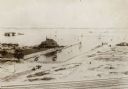
| Date: | 1855 |
|---|---|
| Description: | Bird's-eye view of Madison. "Taken from the Water Cure, South Side of Lake Monona, 1855." |
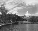
| Date: | 1950 |
|---|---|
| Description: | Exterior view across water towrads the Roger Williams Inn. |
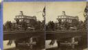
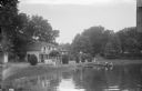
| Date: | 1880 |
|---|---|
| Description: | Stereograph of the Townsend House, a resort hotel. In the foreground there are three people in a rowboat, rowing under a bridge where four other people are... |
| Date: | 1895 |
|---|---|
| Description: | View from across railroad tracks. Resort is on the water's edge, with a small inlet on the right. Land is mostly sand, though a small part on the left ha... |
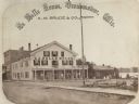
| Date: | 1867 |
|---|---|
| Description: | A summer resort, situated on the banks of Fowler and La Belle Lakes, in the village of Oconomowoc, thirty miles from Milwaukee on the St. Paul R.R. Men sta... |

| Date: | 1926 |
|---|---|
| Description: | This brochure was intended for tourists and shows resorts, lakes and railroads in northwestern Wisconsin and part of Michigan’s upper peninsula. Also inclu... |

| Date: | 1960 |
|---|---|
| Description: | This map shows public boat ramps, parks, highways, beaches, bluffs, Green Bay, Garrett Bay, Europe Bay and Lake, Rowley's Bay and Ellison Bay. The map incl... |

| Date: | 1994 |
|---|---|
| Description: | This map shows historical sites, picnic grounds, public boat landings, canoe and motor boat trips, and resort locations. The left margin of the map include... |
| Date: | |
|---|---|
| Description: | View across water towards a section of Sandy Beach Resort. There are people on the lawn on the left next to buildings. Two women are talking on a porch in ... |

| Date: | 1976 |
|---|---|
| Description: | This colored map displays Wisconsin and portions of bordering states, including a detailed map of the Wisconsin Dells area. Surrounding the map are multipl... |

| Date: | 1977 |
|---|---|
| Description: | This colored map displays Wisconsin and portions of bordering states, including a detailed map of the Wisconsin Dells area. Surrounding the map are multipl... |
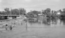
| Date: | 06 1938 |
|---|---|
| Description: | View across water on a sunny day, where many anglers are fishing below the Indian Ford dam and bridge on the Rock river. Some of the men are fishing from t... |

| Date: | 05 31 1938 |
|---|---|
| Description: | Text on front reads: "Sunflower Resort from Long Lake. Near Stone Lake, Wis." Cottages above the shore of a lake through the trees. Docks and boats are on ... |

| Date: | 1907 |
|---|---|
| Description: | Text on front reads: "Gonring's Resort at Cedar Lake near West Bend, Wis." Two-story clapboard lodging with a covered porch on the left. A rowboat is pulle... |
If you didn't find the material you searched for, our Library Reference Staff can help.
Call our reference desk at 608-264-6535 or email us at: