 Filter: Subject of resorts
Filter: Subject of cities and towns
Filter: Subject of canoes and canoeing
Filter: Subject of resorts
Filter: Subject of cities and towns
Filter: Subject of canoes and canoeing

| Date: | 1952 |
|---|---|
| Description: | This map shows roads, foot and canoe trails, railroads, resorts, lookout towers, camps, national and state forests, Indian reservation, and types of fish i... |

| Date: | 1921 |
|---|---|
| Description: | This map shows in red the NorthWestern Railway Line routes running from Chicago, Illinois to northern Wisconsin and Michigan. The map includes cities and t... |

| Date: | 1922 |
|---|---|
| Description: | This map shows in red the NorthWestern Railway Line routes running from Chicago, Illinois to northern Wisconsin. The map includes cities and towns, lakes, ... |
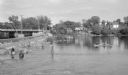
| Date: | 06 1938 |
|---|---|
| Description: | View across water on a sunny day, where many anglers are fishing below the Indian Ford dam and bridge on the Rock river. Some of the men are fishing from t... |

| Date: | |
|---|---|
| Description: | Map showing the location of the Little Bohemia lodge and restaurant, with major routes from Chicago and eastern and central Wisconsin. |
If you didn't find the material you searched for, our Library Reference Staff can help.
Call our reference desk at 608-264-6535 or email us at: