 Filter: Subject of resorts
Filter: Subject of cities and towns
Filter: Subject of tourism
Filter: Subject of resorts
Filter: Subject of cities and towns
Filter: Subject of tourism

| Date: | 1886 |
|---|---|
| Description: | Bird's-eye map of Baraboo with inset of Devil's Lake, the south and east sides of the commercial square, the First National Bank, and the Warren House hote... |

| Date: | 1925 |
|---|---|
| Description: | This brochure intended for tourists and shows resorts, lakes and railroads in northwestern Wisconsin and part of Michigan’s upper peninsula. Two inset maps... |

| Date: | 1950 |
|---|---|
| Description: | This road map shows federal, state and county roads in Wisconsin, northern Illinois, northeastern Iowa, eastern Minnesota, and the western portion of Michi... |

| Date: | 1949 |
|---|---|
| Description: | This 1949 tourism brochure for the Hayward region includes a directory of members of the Hayward Lakes Resort Association, color illustrations, descriptive... |

| Date: | 1977 |
|---|---|
| Description: | This pictorial map was produced by the Chateau, a resort in La Pointe, and shows Madeline Island landmarks and tourist attractions. On the verso is the spr... |

| Date: | 1926 |
|---|---|
| Description: | This 1926 map depicts resorts and camps, lakes and streams, railroads, and roads in portions of Vilas, Iron, Oneida, Price, and Lincoln counties in Wiscons... |

| Date: | 1941 |
|---|---|
| Description: | This 1941 map covers Washburn County, Wisconsin, as well as western Sawyer, eastern Burnett, and northeastern Polk counties. It shows the locations of tour... |

| Date: | 1955 |
|---|---|
| Description: | This 1950s tourist brochure features a map of Burnett County, Wisconsin, and northern Polk County which shows highways and roads, railroads, landmarks, and... |

| Date: | 1938 |
|---|---|
| Description: | This tourist map of Door County, Wisconsin, lists the points of interest and resorts in the area. An inset location map is included. |
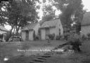
| Date: | |
|---|---|
| Description: | Two guest cabins, with stone steps leading up to them. A lawn swing is behind bushes, and an automobile is parked on the left. |

| Date: | |
|---|---|
| Description: | Duplex cottage with automobiles parked in the back and on the left. Flowers are in window boxes. |
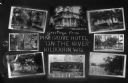
| Date: | 1926 |
|---|---|
| Description: | Composite postcard with eight images of the Pine Grove Hotel and cottages, and views of the Wisconsin River. Caption reads: "Greetings from Pine Grove Hote... |

| Date: | |
|---|---|
| Description: | View from street of the Shell Station at Wee Hoose. |

| Date: | |
|---|---|
| Description: | View across road of the cottages at the White House Hotel, with an information kiosk along the sidewalk between them. A group of people are in front of the... |

| Date: | 1931 |
|---|---|
| Description: | View of a row of cottages on the left side along a sidewalk. The property is bordered by white picket fences. There is a row of stones in front along edge ... |

| Date: | 1931 |
|---|---|
| Description: | View from road of the guest cottages on both sides of the lawn. The property is bordered by white picket fences, and there is a row of stones in front alon... |

| Date: | |
|---|---|
| Description: | View across sidewalk of the courtyard of the White House Hotel. The Annex is on the right. A gazebo is on the left, there are benches and a lawn swing in t... |

| Date: | 1926 |
|---|---|
| Description: | This brochure was intended for tourists and shows resorts, lakes and railroads in northwestern Wisconsin and part of Michigan’s upper peninsula. Also inclu... |

| Date: | 1939 |
|---|---|
| Description: | This brochure was intended for tourists and shows resorts, lakes and railroads in northwestern Wisconsin and part of Michigan’s upper peninsula. Also inclu... |

| Date: | 1969 |
|---|---|
| Description: | This map shows ski areas, resorts, camps, special areas, airports, and roads. The map covers Vilas and Oneida counties and parts of Iron, Price, Lincoln, L... |
If you didn't find the material you searched for, our Library Reference Staff can help.
Call our reference desk at 608-264-6535 or email us at: