 Filter: Subject of resorts
Filter: Subject of cities and towns
Filter: Subject of resorts
Filter: Subject of cities and towns
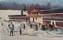
| Date: | 1905 |
|---|---|
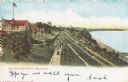
| Description: | Elevated view of people walking on a path by the Whitefish Bay Resort along the lake front. Caption reads: "Whitefish Bay Resort, Milwaukee." |
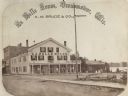
| Date: | 1867 |
|---|---|
| Description: | A summer resort, situated on the banks of Fowler and La Belle Lakes, in the village of Oconomowoc, thirty miles from Milwaukee on the St. Paul R.R. Men sta... |
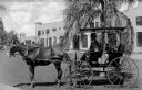
| Date: | |
|---|---|
| Description: | Using a surrey as a taxi for a resort hotel, a man poses in the covered carriage in front of a tree. The city of Howey was founded in 1925, but its name ch... |
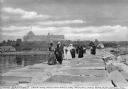
| Date: | 1910 |
|---|---|
| Description: | A group of adults, mostly women, walk along the Rockland Breakwater. The Samoset Resort is in the background on the shoreline. Caption reads: "The Samoset ... |

| Date: | 1860 |
|---|---|
| Description: | Stereograph of the Townsend House boathouse across a lake. |

| Date: | 07 18 1915 |
|---|---|
| Description: | Black and white postcard of Moore's Lakeside Resort on Brown's Lake. Staff and/or visitors are posing on the front porch and on the lawn. The wrap-around b... |

| Date: | |
|---|---|
| Description: | Color postcard of an aerial view of Cerami's Island View Hotel Motel Resort on the shore of Brown's Lake. |
| Date: | |
|---|---|
| Description: | Color postcard of the Chalet at Mt. Telemark. Skiers and skis are in front of the Chalet. |

| Date: | 1925 |
|---|---|
| Description: | This brochure intended for tourists and shows resorts, lakes and railroads in northwestern Wisconsin and part of Michigan’s upper peninsula. Two inset maps... |
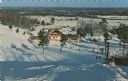
| Date: | |
|---|---|
| Description: | Color postcard of an elevated view of the Chalet at Mt. Telemark and surrounding area, and many skiers and several ski lifts. |

| Date: | |
|---|---|
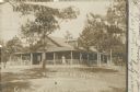
| Description: | Photographic postcard of the Ingleside Resort on Lake Ripley. There is a porch on the cabin, and several hammocks are strung on trees on the lawn. Caption ... |

| Date: | 1903 |
|---|---|
| Description: | A map of northern Wisconsin and Michigan showing the names and locations hunting and fishing resorts in the area, as well as location of Chicago and North ... |

| Date: | 1904 |
|---|---|
| Description: | A map that shows the location of the lakes and resorts in northeastern Wisconsin that were reachable by the Chicago and North Western Railway. Shown in the... |

| Date: | 1914 |
|---|---|
| Description: | Two maps of northern Wisconsin counties of Ashland, Barron, Bayfield, Chippewa, Douglas, Forest, Iron, Langlade, Lincoln, Oneida, Polk, Price, Sawyer, Tayl... |
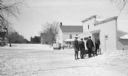
| Date: | 02 1924 |
|---|---|
| Description: | Three men stand behind a horse-drawn enclosed sleigh in front of the Lundberg Store on Fish Creek's Main Street. There is a second sleigh and horse in the ... |

| Date: | 1950 |
|---|---|
| Description: | This road map shows federal, state and county roads in Wisconsin, northern Illinois, northeastern Iowa, eastern Minnesota, and the western portion of Michi... |
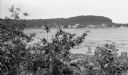
| Date: | 1907 |
|---|---|
| Description: | View across Fish Creek Harbor to the village of Fish Creek and its pier, with warehouse. On the right is Dr. Weckler's Resort, a large wooden building with... |
| Date: | 09 05 1908 |
|---|---|
| Description: | Photographic postcard of Range House, a large rustic log cabin. There is a large porch on all sides of the building with interesting roof supports and rail... |

| Date: | 1891 |
|---|---|
| Description: | A hand-colored map of Milwaukee County, Wisconsin that shows the township and range system, sections, towns, roads, railroads and rail stations, cities and... |

| Date: | 1914 |
|---|---|
| Description: | This 1914 map of Price County, Wisconsin, shows land for sale by the Good Land Company and Dewitt van Ostrand of Phillips. Also shown are the township and ... |
If you didn't find the material you searched for, our Library Reference Staff can help.
Call our reference desk at 608-264-6535 or email us at: