 Filter: Subject of resorts
Filter: Subject of electric power
Filter: Subject of resorts
Filter: Subject of electric power
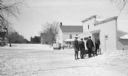
| Date: | 02 1924 |
|---|---|
| Description: | Three men stand behind a horse-drawn enclosed sleigh in front of the Lundberg Store on Fish Creek's Main Street. There is a second sleigh and horse in the ... |

| Date: | 1918 |
|---|---|
| Description: | This map shows counties, cities, towns, villages, summer resorts, lakes, rivers, creeks, wagon roads, roads, railroads, and electric lines. The authentic a... |
If you didn't find the material you searched for, our Library Reference Staff can help.
Call our reference desk at 608-264-6535 or email us at: