| Date: | 1930 |
|---|---|
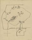
| Description: | This manuscript map, likely drawn in the 1930s, shows Fox Lake, in Dodge County, Wisconsin, and the roads and resorts in the vicinity. |

| Date: | 1943 |
|---|---|
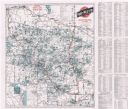
| Description: | This map shows roads, trails, taverns, schools, golf, gas stations, campsites, resorts, and towers. The lower left of the map includes a legend. The map co... |

| Date: | 1941 |
|---|---|
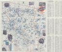
| Description: | This map highlights the fishing district and shows labeled rivers, lakes, cities, county boundaries and points of interest. The map includes a list of trai... |

| Date: | 1922 |
|---|---|
| Description: | This map shows in red the NorthWestern Railway Line routes running from Chicago, Illinois to northern Wisconsin. The map includes cities and towns, lakes, ... |
If you didn't find the material you searched for, our Library Reference Staff can help.
Call our reference desk at 608-264-6535 or email us at: