 Filter: Subject of resorts
Filter: Subject of intellectual life
Filter: Subject of lakes
Filter: Subject of resorts
Filter: Subject of intellectual life
Filter: Subject of lakes

| Date: | 1855 |
|---|---|
| Description: | Bird's-eye view of Madison. "Taken from the Water Cure, South Side of Lake Monona, 1855." |

| Date: | 1870 |
|---|---|
| Description: | Bird's-eye map of Madison. The Lakeside House resort is in the foreground, which burned in 1877, in what is now Olin Park. |

| Date: | 1890 |
|---|---|
| Description: | Colored bird's-eye map of Oconomowoc and the Lake Region, Waukesha County. Looking North from Government Hill. Location key below image identifies 24 Hotel... |

| Date: | 1886 |
|---|---|
| Description: | Bird's-eye map of Baraboo with inset of Devil's Lake, the south and east sides of the commercial square, the First National Bank, and the Warren House hote... |
| Date: | 1955 |
|---|---|
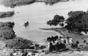
| Description: | Aerial view of Treeland Pines resort on Lake Chippewa. Caption reads: "Air View of Bob Cammack's Treeland Pines Resort; Lake Chippewa, Hayward, Wis." |
| Date: | 1955 |
|---|---|
| Description: | Aerial view of Treeland Pines Resort on Lake Chippewa. Caption reads: "Aerial View of Treeland Pines Resort on Lake Chippewa (The Flowage), Hayward, Wis." |
| Date: | 1930 |
|---|---|
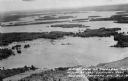
| Description: | Aerial view of Lake Delton and shoreline including resort areas. |

| Date: | 1935 |
|---|---|
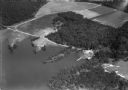
| Description: | Aerial view of Alex LeTourneau's Resort on Spider Lake. |

| Date: | |
|---|---|
| Description: | Color postcard of an aerial view of Cerami's Island View Hotel Motel Resort on the shore of Brown's Lake. |

| Date: | |
|---|---|
| Description: | Color postcard of an aerial view of the Lakewoods Family Resort on Lake Namekagon. All modern housekeeping cottages with an indoor heated swimming pool. |

| Date: | 1930 |
|---|---|
| Description: | Aerial photographic postcard of Jack O'Lantern Lodge on Taylor Lake east of Eagle River on STH70, including the forest area surrounding the shoreline. Capt... |

| Date: | 1930 |
|---|---|
| Description: | Original map made with watercolor and inkwash. Includes a legend of buildings, roads, natural features and other details of the lodge. Inset at bottom has ... |

| Date: | 1935 |
|---|---|
| Description: | This blue lined map shows the major roads and cities of Wisconsin. The map includes an index, hotel and cafe advertisements, as well as advertisements for ... |

| Date: | 1935 |
|---|---|
| Description: | This blue lined map ("compliments of Black Eagle Oil Company") shows the major roads and cities of Wisconsin. The map includes an index, hotel and cafe adv... |

| Date: | 1930 |
|---|---|
| Description: | This map shows roads and lakes and includes an inset illustration of Manitowish Waters Fish Hatchery. The back of the map includes a resorts directory, tex... |

| Date: | 1975 |
|---|---|
| Description: | This map shows nature trails, public attractions, public hunting and fishing grounds, dams, waysides, lakes, highways, and roads. The upper right corner in... |

| Date: | 1941 |
|---|---|
| Description: | This map highlights the fishing district and shows labeled rivers, lakes, cities, county boundaries and points of interest. The map includes a list of trai... |

| Date: | 1918 |
|---|---|
| Description: | Hand-colored elevated view of Steges Home Resort, including the main building, pavilion and boat house on the shoreline. Caption reads: "Steges Home Resort... |

| Date: | |
|---|---|
| Description: | Aerial view of a resort on the shore of Elkhart Lake. Caption reads: "Aerial View Sharpe's Resort, Elkhart Lake, Wis." |
| Date: | |
|---|---|
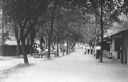
| Description: | View of groups of people sitting at picnic tables under rows of trees that lead down to a lake at a resort. More people are standing or walking near buildi... |
If you didn't find the material you searched for, our Library Reference Staff can help.
Call our reference desk at 608-264-6535 or email us at: