 Filter: Subject of resorts
Filter: Subject of islands
Filter: Subject of resorts
Filter: Subject of islands

| Date: | 1890 |
|---|---|
| Description: | Colored bird's-eye map of Oconomowoc and the Lake Region, Waukesha County. Looking North from Government Hill. Location key below image identifies 24 Hotel... |
| Date: | 1890 |
|---|---|
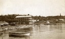
| Description: | Old Mission Inn and boats on shoreline of Lake Superior on Madeline Island. The Old Mission Inn had numerous modifications over the years. It was razed in... |
| Date: | 1955 |
|---|---|
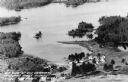
| Description: | Aerial view of Treeland Pines resort on Lake Chippewa. Caption reads: "Air View of Bob Cammack's Treeland Pines Resort; Lake Chippewa, Hayward, Wis." |
| Date: | 1955 |
|---|---|
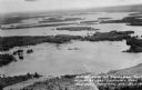
| Description: | Aerial view of Treeland Pines Resort on Lake Chippewa. Caption reads: "Aerial View of Treeland Pines Resort on Lake Chippewa (The Flowage), Hayward, Wis." |
| Date: | |
|---|---|
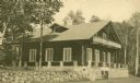
| Description: | Exterior view of a lodge, probably on Rock Island in Door County. Two men pose in front of the building. |

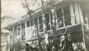
| Date: | 1948 |
|---|---|
| Description: | View from a pier of rowboats and a cabin at the Island Resort on Lake Ripley. |
| Date: | |
|---|---|
| Description: | Elevated view overlooking a road leading toward water, a boathouse, cabins, and a lake, most likely Jackson Lake. The shoreline on the far top right is ide... |

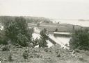
| Date: | |
|---|---|
| Description: | View of a dirt road, cleared land, Jackson Lake and shoreline. Off to the far right is where the Nature Lovers Paradise resort cottages were located. A sig... |
| Date: | 1915 |
|---|---|
| Description: | Exterior view of Hull Cottage, also known as Coole Park Manor, on Madeline Island. |

| Date: | |
|---|---|
| Description: | Colorized postcard view over water towards boats and boaters at a resort. In the background are people and boats near a pier. The resort is among trees on ... |

| Date: | 1910 |
|---|---|
| Description: | This map shows shoreline lot numbers and acreages, the Wisconsin River, and the Michigan and Wisconsin state line. Manuscript annotations relating to topon... |

| Date: | 1907 |
|---|---|
| Description: | Hand-colored view across water towards three islands in big Cedar Lake. The center island has a resort building with a red roof. |

| Date: | 1940 |
|---|---|
| Description: | A motor boat carrying three people is leaving a small wake in the calm waters of Crawling Stone Lake as it heads toward an island. There is a worn wooden p... |

| Date: | 1975 |
|---|---|
| Description: | Colored bird's-eye map of the Lake Region of Waukesha County. Looking North from Government Hill. All these Lakes and Resorts are withing Four hours ride o... |
If you didn't find the material you searched for, our Library Reference Staff can help.
Call our reference desk at 608-264-6535 or email us at:
