 Filter: Subject of resorts
Filter: Subject of lakes
Filter: Subject of hotels
Filter: Subject of resorts
Filter: Subject of lakes
Filter: Subject of hotels

| Date: | 1890 |
|---|---|
| Description: | Colored bird's-eye map of Oconomowoc and the Lake Region, Waukesha County. Looking North from Government Hill. Location key below image identifies 24 Hotel... |

| Date: | 1886 |
|---|---|
| Description: | Bird's-eye map of Baraboo with inset of Devil's Lake, the south and east sides of the commercial square, the First National Bank, and the Warren House hote... |
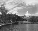
| Date: | 1950 |
|---|---|
| Description: | Exterior view across water towrads the Roger Williams Inn. |
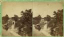
| Date: | 1860 |
|---|---|
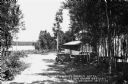
| Description: | Stereograph of the Townsend House boathouse across a lake. |
| Date: | 1860 |
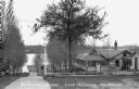
|---|---|
| Description: | Stereograph of Townsend House. Image includes people sitting on porch, grounds, boat dock. |

| Date: | |
|---|---|
| Description: | View of the Cliff House, a resort near Devil's Lake. Caption on stereograph reads: "Devil's Lake and Vicinity. Views of the Cliff House, from the beach." |
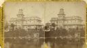
| Date: | 1925 |
|---|---|
| Description: | A copy of an original photograph by H.H. Bennett of the Cliff House Inn at Devil's Lake as seen from the beach. Abraham Lincoln is reported to have slept h... |

| Date: | 1860 |
|---|---|
| Description: | Stereograph of the Townsend House boathouse across a lake. |

| Date: | |
|---|---|
| Description: | Color postcard of an aerial view of Cerami's Island View Hotel Motel Resort on the shore of Brown's Lake. |
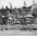
| Date: | 1934 |
|---|---|
| Description: | Exterior view of the Norseman Lodge with Lake Millicent visible in the background. The larger building on the right has a sign that says "Hotel." A bird ho... |
| Date: | 1931 |
|---|---|
| Description: | View down drive towards lake. The front porch is behind a grove of trees where automobiles are parked out front of the Northwood's Beach Hotel on Lake Cour... |

| Date: | 1950 |
|---|---|
| Description: | This road map shows federal, state and county roads in Wisconsin, northern Illinois, northeastern Iowa, eastern Minnesota, and the western portion of Michi... |

| Date: | 1926 |
|---|---|
| Description: | This 1926 map depicts resorts and camps, lakes and streams, railroads, and roads in portions of Vilas, Iron, Oneida, Price, and Lincoln counties in Wiscons... |

| Date: | 1909 |
|---|---|
| Description: | This 1909 map of northern Wisconsin and a portion of Michigan's Upper Peninsula shows the Lac du Flambeau Indian Reservation, cities and villages, railroad... |

| Date: | 1938 |
|---|---|
| Description: | The map includes text, illustrations, a railroad fare table (season 1938), a Directory of resorts and hotels, and a regional map on the back. |
| Date: | 1910 |
|---|---|
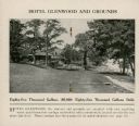
| Description: | The centerfold of a promotional brochure features a photograph of the Hotel Glenwood and a description of the springs on the grounds. The hotel, with large... |

| Date: | 1853 |
|---|---|
| Description: | This map shows camps, forts, logging camps, lakes, roads, railroads, the Wisconsin River, and Lac Du Flambeau Indian Reservation. Some points of interest a... |

| Date: | 1926 |
|---|---|
| Description: | This brochure was intended for tourists and shows resorts, lakes and railroads in northwestern Wisconsin and part of Michigan’s upper peninsula. Also inclu... |

| Date: | 1939 |
|---|---|
| Description: | This brochure was intended for tourists and shows resorts, lakes and railroads in northwestern Wisconsin and part of Michigan’s upper peninsula. Also inclu... |
| Date: | 1885 |
|---|---|
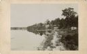
| Description: | View along shoreline towards Tonyawatha House and several outbuildings on Lake Monona. There is a long dock extending into the lake from a boathouse on the... |
If you didn't find the material you searched for, our Library Reference Staff can help.
Call our reference desk at 608-264-6535 or email us at: