 Filter: Subject of resorts
Filter: Subject of lakes
Filter: Subject of state parks and reserves
Filter: Subject of resorts
Filter: Subject of lakes
Filter: Subject of state parks and reserves

| Date: | |
|---|---|
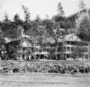
| Description: | View of the Cliff House, a resort near Devil's Lake. Caption on stereograph reads: "Devil's Lake and Vicinity. Views of the Cliff House, from the beach." |
| Date: | 1925 |
|---|---|
| Description: | A copy of an original photograph by H.H. Bennett of the Cliff House Inn at Devil's Lake as seen from the beach. Abraham Lincoln is reported to have slept h... |

| Date: | 1950 |
|---|---|
| Description: | This road map shows federal, state and county roads in Wisconsin, northern Illinois, northeastern Iowa, eastern Minnesota, and the western portion of Michi... |

| Date: | 1991 |
|---|---|
| Description: | This 1991 map of Burnett County, Wisconsin, shows Governor Knowles State Forest, wildlife areas, public hunting grounds, and other outdoor recreation facil... |

| Date: | 1952 |
|---|---|
| Description: | This map shows roads, foot and canoe trails, railroads, resorts, lookout towers, camps, national and state forests, Indian reservation, and types of fish i... |

| Date: | 1930 |
|---|---|
| Description: | Men, women and children in modest swimming suits enjoy splashing and playing in the water at Sandy Beach, a resort established by Gerhard Strauss in 1921. ... |
If you didn't find the material you searched for, our Library Reference Staff can help.
Call our reference desk at 608-264-6535 or email us at: