 Filter: Subject of resorts
Filter: Subject of outdoor recreation
Filter: Subject of resorts
Filter: Subject of outdoor recreation
| Date: | 1938 |
|---|---|
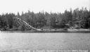
| Description: | A large slide at Pease's Resort on the shore of the Upper Eau Claire Lake. Children are in the water near stairs that go up the hill. |

| Date: | 1925 |
|---|---|
| Description: | This brochure intended for tourists and shows resorts, lakes and railroads in northwestern Wisconsin and part of Michigan’s upper peninsula. Two inset maps... |

| Date: | 1958 |
|---|---|
| Description: | Includes images of Flambeau River State Forest and a description of, canoeing and recreational activities in, and general park and forest information about... |

| Date: | 1949 |
|---|---|
| Description: | This 1949 tourism brochure for the Hayward region includes a directory of members of the Hayward Lakes Resort Association, color illustrations, descriptive... |

| Date: | 1991 |
|---|---|
| Description: | This 1991 map of Burnett County, Wisconsin, shows Governor Knowles State Forest, wildlife areas, public hunting grounds, and other outdoor recreation facil... |

| Date: | |
|---|---|
| Description: | Colorized postcard view over water towards boats and boaters at a resort. In the background are people and boats near a pier. The resort is among trees on ... |
| Date: | |
|---|---|
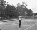
| Description: | Two men playing tennis on the Birchcliff Hotel tennis court. Another group of guests are playing croquet on the lawn in the background. People relax on cha... |
| Date: | |
|---|---|
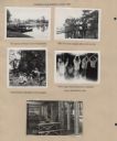
| Description: | Page from Sue Ann Hackett Blue Album displaying several scenes from a canoe trip on the Lower Kaubashine Creek. Includes photographs of Joy Camps canoes on... |

| Date: | 1939 |
|---|---|
| Description: | This brochure was intended for tourists and shows resorts, lakes and railroads in northwestern Wisconsin and part of Michigan’s upper peninsula. Also inclu... |

| Date: | 1969 |
|---|---|
| Description: | This map shows ski areas, resorts, camps, special areas, airports, and roads. The map covers Vilas and Oneida counties and parts of Iron, Price, Lincoln, L... |

| Date: | 1976 |
|---|---|
| Description: | This colored map displays Wisconsin and portions of bordering states, including a detailed map of the Wisconsin Dells area. Surrounding the map are multipl... |

| Date: | 1977 |
|---|---|
| Description: | This colored map displays Wisconsin and portions of bordering states, including a detailed map of the Wisconsin Dells area. Surrounding the map are multipl... |
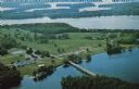
| Date: | 1950 |
|---|---|
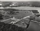
| Description: | Aerial view of Northernaire Resort, on Deer Lake. The resort is in the foreground. Many lakes, surrounded by trees, are in the background, including Big St... |
| Date: | 1963 |
|---|---|
| Description: | Text on reverse reads: "Northernaire, Three Lakes, WI 54562. Phone 715 – 546-3331. The Resort Hotel that has it all." Aerial view of Northernaire Resort, o... |
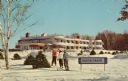
| Date: | 1961 |
|---|---|
| Description: | Text on reverse reads: "Northernaire, Three Lakes, Wisconsin. Open Year 'Round." View of Northernaire Resort, on Deer Lake, an Art Moderne hotel built in 1... |
If you didn't find the material you searched for, our Library Reference Staff can help.
Call our reference desk at 608-264-6535 or email us at: