 Filter: Subject of resorts
Filter: Subject of parks
Filter: Subject of tourism
Filter: Subject of resorts
Filter: Subject of parks
Filter: Subject of tourism
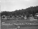
| Date: | 1925 |
|---|---|
| Description: | View of two-seat lawn swings amid trees on a lawn. Cabins are along a hill in the background. There is an information center on the far left. |
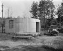
| Date: | 1927 |
|---|---|
| Description: | A cylinder-shaped cement building with an open door in a rural area. In front of the building is a picnic table, and on the right an automobile is parked n... |

| Date: | 1961 |
|---|---|
| Description: | This map shows the lake, clubs, resorts, motels, school house, public approaches, and public parks. The back of map includes advertisements and text. |

| Date: | 1960 |
|---|---|
| Description: | This map shows public boat ramps, parks, highways, beaches, bluffs, Green Bay, Garrett Bay, Europe Bay and Lake, Rowley's Bay and Ellison Bay. The map incl... |

| Date: | 1977 |
|---|---|
| Description: | This colored map displays Wisconsin and portions of bordering states, including a detailed map of the Wisconsin Dells area. Surrounding the map are multipl... |
If you didn't find the material you searched for, our Library Reference Staff can help.
Call our reference desk at 608-264-6535 or email us at: