 Filter: Subject of resorts
Filter: Subject of recreation
Filter: Subject of cities and towns
Filter: Subject of resorts
Filter: Subject of recreation
Filter: Subject of cities and towns

| Date: | 1920 |
|---|---|
| Description: | View of the main building in the distance, and in the foreground a golf course of the Moor (Mud) Baths. Caption reads: "Main Bldg., Moor (Mud) Baths, Wauke... |

| Date: | 1920 |
|---|---|
| Description: | View of people sitting on the porch of the golf club house at the Moor Bath Links. Caption reads: "Club House, Waukesha Golf Club on Moor Bath Links, Wauke... |
| Date: | 1914 |
|---|---|
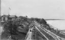
| Description: | Elevated view of Pabst Whitefish Bay Resort on the shores of Lake Michigan, with crowds of individuals walking up the numerous paths that lead to the resor... |
| Date: | 1895 |
|---|---|
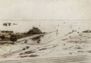
| Description: | View from across railroad tracks. Resort is on the water's edge, with a small inlet on the right. Land is mostly sand, though a small part on the left ha... |
| Date: | 1910 |
|---|---|
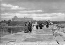
| Description: | A group of adults, mostly women, walk along the Rockland Breakwater. The Samoset Resort is in the background on the shoreline. Caption reads: "The Samoset ... |
| Date: | |
|---|---|
| Description: | Color postcard of the Chalet at Mt. Telemark. Skiers and skis are in front of the Chalet. |

| Date: | 1925 |
|---|---|
| Description: | This brochure intended for tourists and shows resorts, lakes and railroads in northwestern Wisconsin and part of Michigan’s upper peninsula. Two inset maps... |
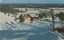
| Date: | |
|---|---|
| Description: | Color postcard of an elevated view of the Chalet at Mt. Telemark and surrounding area, and many skiers and several ski lifts. |

| Date: | 1903 |
|---|---|
| Description: | A map of northern Wisconsin and Michigan showing the names and locations hunting and fishing resorts in the area, as well as location of Chicago and North ... |

| Date: | 1914 |
|---|---|
| Description: | Two maps of northern Wisconsin counties of Ashland, Barron, Bayfield, Chippewa, Douglas, Forest, Iron, Langlade, Lincoln, Oneida, Polk, Price, Sawyer, Tayl... |

| Date: | 1949 |
|---|---|
| Description: | This 1949 tourism brochure for the Hayward region includes a directory of members of the Hayward Lakes Resort Association, color illustrations, descriptive... |

| Date: | 1926 |
|---|---|
| Description: | This 1926 map depicts resorts and camps, lakes and streams, railroads, and roads in portions of Vilas, Iron, Oneida, Price, and Lincoln counties in Wiscons... |

| Date: | 1991 |
|---|---|
| Description: | This 1991 map of Burnett County, Wisconsin, shows Governor Knowles State Forest, wildlife areas, public hunting grounds, and other outdoor recreation facil... |

| Date: | 1940 |
|---|---|
| Description: | Map shows hydrography and location of game fish in part of Vilas County, Wisconsin and Gogebic County, Michigan. |

| Date: | 1953 |
|---|---|
| Description: | This mid 20th century map of Vilas County and northeastern Oneida County, Wisconsin, shows the township and range grid, sections, cities and villages, rail... |
| Date: | |
|---|---|
| Description: | Two guest cabins, with stone steps leading up to them. A lawn swing is behind bushes, and an automobile is parked on the left. |

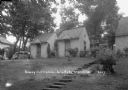
| Date: | |
|---|---|
| Description: | View across sidewalk of the courtyard of the White House Hotel. The Annex is on the right. A gazebo is on the left, there are benches and a lawn swing in t... |

| Date: | 1926 |
|---|---|
| Description: | This brochure was intended for tourists and shows resorts, lakes and railroads in northwestern Wisconsin and part of Michigan’s upper peninsula. Also inclu... |

| Date: | 1939 |
|---|---|
| Description: | This brochure was intended for tourists and shows resorts, lakes and railroads in northwestern Wisconsin and part of Michigan’s upper peninsula. Also inclu... |

| Date: | 1952 |
|---|---|
| Description: | This map shows roads, foot and canoe trails, railroads, resorts, lookout towers, camps, national and state forests, Indian reservation, and types of fish i... |
If you didn't find the material you searched for, our Library Reference Staff can help.
Call our reference desk at 608-264-6535 or email us at: