 Filter: Subject of resorts
Filter: Subject of recreation
Filter: Subject of roads
Filter: Subject of resorts
Filter: Subject of recreation
Filter: Subject of roads

| Date: | |
|---|---|
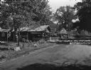
| Description: | A view of the inn, casino, and other structures at The Oakbirch Inn and Casino taken from a tree-lined road. A man sits in the passenger side of a car park... |
| Date: | 1925 |
|---|---|
| Description: | An information station advertising: free camping, with hot sandwiches and coffee, and tents and cots for sale. On a utility line pole, there are signs for ... |
| Date: | 1935 |
|---|---|
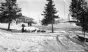
| Description: | Winter scene with people sledding, dog sledding, snowshoeing, and preparing for snowshoeing at Lakewood Country Club. |
| Date: | 1934 |
|---|---|
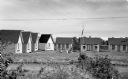
| Description: | View of seven small cabins around a clearing where there is an American flag on a flag pole and two benches around a stone fire pit. In the foreground is a... |

| Date: | 1958 |
|---|---|
| Description: | Includes images of Flambeau River State Forest and a description of, canoeing and recreational activities in, and general park and forest information about... |

| Date: | 1916 |
|---|---|
| Description: | This map shows the locations of hunting and fishing resorts in the northern Wisconsin counties of Forest, Iron, Oneida, and Vilas, and in Gogebic County in... |
| Date: | 1929 |
|---|---|
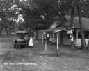
| Description: | A man, woman, and child pose by a car near a tourist camping stop. |
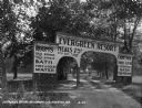
| Date: | 1929 |
|---|---|
| Description: | The entrance way to the Evergreen Resort. The sign advertises rooms, hot and cold water baths, meals, camp sites, and tourist kitchens. Caption reads: "Eve... |

| Date: | 1949 |
|---|---|
| Description: | This 1949 tourism brochure for the Hayward region includes a directory of members of the Hayward Lakes Resort Association, color illustrations, descriptive... |

| Date: | 1926 |
|---|---|
| Description: | This 1926 map depicts resorts and camps, lakes and streams, railroads, and roads in portions of Vilas, Iron, Oneida, Price, and Lincoln counties in Wiscons... |

| Date: | 1991 |
|---|---|
| Description: | This 1991 map of Burnett County, Wisconsin, shows Governor Knowles State Forest, wildlife areas, public hunting grounds, and other outdoor recreation facil... |

| Date: | 1930 |
|---|---|
| Description: | This manuscript map, likely drawn in the 1930s, shows Fox Lake, in Dodge County, Wisconsin, and the roads and resorts in the vicinity. |

| Date: | 1953 |
|---|---|
| Description: | This mid 20th century map of Vilas County and northeastern Oneida County, Wisconsin, shows the township and range grid, sections, cities and villages, rail... |

| Date: | 1929 |
|---|---|
| Description: | View across road of cottage with a screened porch in a wooded area. Picnic tables are on the left. A bench is in front of the cottage. A row of planters in... |

| Date: | |
|---|---|
| Description: | View across road towards the stone steps leading up a hill to the main building of the Birchcliff Hotel. A lawn swing is on top of the hill to the left of ... |

| Date: | |
|---|---|
| Description: | Group portrait of five riders on horses posing on the road in front of two guest cottages. A young girl is standing on the left. |

| Date: | 1927 |
|---|---|
| Description: | View of the entrance drive of the Grandview Hotel. There is a large signboard advertising the amenities; rooms with baths, hot and cold water, cottages and... |

| Date: | 1952 |
|---|---|
| Description: | This map shows roads, foot and canoe trails, railroads, resorts, lookout towers, camps, national and state forests, Indian reservation, and types of fish i... |

| Date: | 1969 |
|---|---|
| Description: | This map shows ski areas, resorts, camps, special areas, airports, and roads. The map covers Vilas and Oneida counties and parts of Iron, Price, Lincoln, L... |
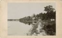
| Date: | 1885 |
|---|---|
| Description: | View along shoreline towards Tonyawatha House and several outbuildings on Lake Monona. There is a long dock extending into the lake from a boathouse on the... |
If you didn't find the material you searched for, our Library Reference Staff can help.
Call our reference desk at 608-264-6535 or email us at: