 Filter: Subject of resorts
Filter: Subject of rivers
Filter: Subject of resorts
Filter: Subject of rivers

| Date: | 1991 |
|---|---|
| Description: | This 1991 map of Burnett County, Wisconsin, shows Governor Knowles State Forest, wildlife areas, public hunting grounds, and other outdoor recreation facil... |

| Date: | 1938 |
|---|---|
| Description: | The map includes text, illustrations, a railroad fare table (season 1938), a Directory of resorts and hotels, and a regional map on the back. |

| Date: | 1956 |
|---|---|
| Description: | This map shows Lake Wisconsin, roads, highways, parks, resort areas, camps, gardens, and Wisconsin State experimental game and fur farm. The back of the ma... |

| Date: | 1941 |
|---|---|
| Description: | This is map one of three maps that show trails, roads and fire lanes, utilities, resorts, submerged lakes, vegetation, flowage right lands, and timber righ... |

| Date: | 1941 |
|---|---|
| Description: | This is map three of a set of three, and shows trails, roads and fire lanes, utilities, resorts, submerged lakes, vegetation, flowage right lands, and timb... |

| Date: | 1952 |
|---|---|
| Description: | This map shows roads, foot and canoe trails, railroads, resorts, lookout towers, camps, national and state forests, Indian reservation, and types of fish i... |

| Date: | 1951 |
|---|---|
| Description: | This map shows land use, dwellings, resorts, camps, marshes, springs, dams, lake bottom composition, and access. The map includes a fish species table, geo... |

| Date: | 1969 |
|---|---|
| Description: | This map shows businesses, resorts, roads, public boat landings, schools, cemeteries, and location of fish and game. An inset map reads: Continuation along... |

| Date: | 1918 |
|---|---|
| Description: | This map shows counties, cities, towns, villages, summer resorts, lakes, rivers, creeks, wagon roads, roads, railroads, and electric lines. The authentic a... |

| Date: | 1900 |
|---|---|
| Description: | This map shows logging roads, railroads with spur lines, trails, rapids, lumber camps, Indian villages, summer resort, lakes, rivers, and ponds. |

| Date: | 1935 |
|---|---|
| Description: | This blue lined map ("compliments of Black Eagle Oil Company") shows the major roads and cities of Wisconsin. The map includes an index, hotel and cafe adv... |

| Date: | 1940 |
|---|---|
| Description: | This map shows lakes, roads, car trails, foot trails, railroads, resorts and camps, and fire towers. The map includes an inset location map and pictorial d... |

| Date: | 1975 |
|---|---|
| Description: | This map shows nature trails, public attractions, public hunting and fishing grounds, dams, waysides, lakes, highways, and roads. The upper right corner in... |

| Date: | 1994 |
|---|---|
| Description: | This map shows historical sites, picnic grounds, public boat landings, canoe and motor boat trips, and resort locations. The left margin of the map include... |

| Date: | 1941 |
|---|---|
| Description: | This map highlights the fishing district and shows labeled rivers, lakes, cities, county boundaries and points of interest. The map includes a list of trai... |

| Date: | 1921 |
|---|---|
| Description: | This map shows in red the NorthWestern Railway Line routes running from Chicago, Illinois to northern Wisconsin and Michigan. The map includes cities and t... |

| Date: | 1922 |
|---|---|
| Description: | This map shows in red the NorthWestern Railway Line routes running from Chicago, Illinois to northern Wisconsin. The map includes cities and towns, lakes, ... |

| Date: | 1962 |
|---|---|
| Description: | This tourist-oriented road map shows federal highways, state highways, county roads, and county lines in the "Blue Diamond Resort Area," a scenic space enc... |
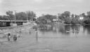
| Date: | 06 1938 |
|---|---|
| Description: | View across water on a sunny day, where many anglers are fishing below the Indian Ford dam and bridge on the Rock river. Some of the men are fishing from t... |
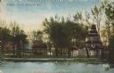
| Date: | 06 16 1909 |
|---|---|
| Description: | Text on front reads: "Bethesda Spring, Waukesha, Wis." Bethesda Spring is located inside an ornate pavilion surrounded by trees. The Terrace Hotel can be s... |
If you didn't find the material you searched for, our Library Reference Staff can help.
Call our reference desk at 608-264-6535 or email us at: