 Filter: Subject of resorts
Filter: Subject of roads
Filter: Subject of hotels
Filter: Subject of resorts
Filter: Subject of roads
Filter: Subject of hotels

| Date: | 1890 |
|---|---|
| Description: | Colored bird's-eye map of Oconomowoc and the Lake Region, Waukesha County. Looking North from Government Hill. Location key below image identifies 24 Hotel... |

| Date: | |
|---|---|
| Description: | Color postcard of an aerial view of Cerami's Island View Hotel Motel Resort on the shore of Brown's Lake. |

| Date: | 1950 |
|---|---|
| Description: | This road map shows federal, state and county roads in Wisconsin, northern Illinois, northeastern Iowa, eastern Minnesota, and the western portion of Michi... |

| Date: | 1926 |
|---|---|
| Description: | This 1926 map depicts resorts and camps, lakes and streams, railroads, and roads in portions of Vilas, Iron, Oneida, Price, and Lincoln counties in Wiscons... |

| Date: | 1909 |
|---|---|
| Description: | This 1909 map of northern Wisconsin and a portion of Michigan's Upper Peninsula shows the Lac du Flambeau Indian Reservation, cities and villages, railroad... |

| Date: | |
|---|---|
| Description: | View across road towards the stone steps leading up a hill to the main building of the Birchcliff Hotel. A lawn swing is on top of the hill to the left of ... |
| Date: | 1927 |
|---|---|
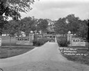
| Description: | Front entrance to the Black Oaks resort. A man is driving an automobile down the drive near two stone walls with columns framing the entrance to the drivew... |

| Date: | 1927 |
|---|---|
| Description: | View of the entrance drive of the Grandview Hotel. There is a large signboard advertising the amenities; rooms with baths, hot and cold water, cottages and... |

| Date: | 1929 |
|---|---|
| Description: | Exterior view of a stone building which has a steep, tiled roof, and an awning over the open doorway under the "Wee Hoose" sign. In front are pumps for She... |

| Date: | 1853 |
|---|---|
| Description: | This map shows camps, forts, logging camps, lakes, roads, railroads, the Wisconsin River, and Lac Du Flambeau Indian Reservation. Some points of interest a... |
| Date: | 1885 |
|---|---|
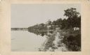
| Description: | View along shoreline towards Tonyawatha House and several outbuildings on Lake Monona. There is a long dock extending into the lake from a boathouse on the... |

| Date: | 1935 |
|---|---|
| Description: | This blue lined map shows the major roads and cities of Wisconsin. The map includes an index, hotel and cafe advertisements, as well as advertisements for ... |

| Date: | 1935 |
|---|---|
| Description: | This blue lined map ("compliments of Black Eagle Oil Company") shows the major roads and cities of Wisconsin. The map includes an index, hotel and cafe adv... |
| Date: | 1963 |
|---|---|
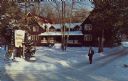
| Description: | Text on reverse reads: "Hotel du Nord, Sister Bay, Wisconsin 54234, Phone (414)854-4221. Winter Scene. AAA. Modern lodge rooms and cottages, all with priva... |

| Date: | 1975 |
|---|---|
| Description: | Colored bird's-eye map of the Lake Region of Waukesha County. Looking North from Government Hill. All these Lakes and Resorts are withing Four hours ride o... |
If you didn't find the material you searched for, our Library Reference Staff can help.
Call our reference desk at 608-264-6535 or email us at: