 Filter: Subject of resorts
Filter: Subject of roads
Filter: Subject of rivers
Filter: Subject of resorts
Filter: Subject of roads
Filter: Subject of rivers
| Date: | 1935 |
|---|---|
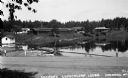
| Description: | Variety of buildings reflected in Teal Lake. A wooden rowboat is tied to a pier on the lake. The Teal River is rushing over a nearby dam and along the dirt... |

| Date: | 1958 |
|---|---|
| Description: | Includes images of Flambeau River State Forest and a description of, canoeing and recreational activities in, and general park and forest information about... |

| Date: | 1950 |
|---|---|
| Description: | This road map shows federal, state and county roads in Wisconsin, northern Illinois, northeastern Iowa, eastern Minnesota, and the western portion of Michi... |

| Date: | 1891 |
|---|---|
| Description: | A hand-colored map of Milwaukee County, Wisconsin that shows the township and range system, sections, towns, roads, railroads and rail stations, cities and... |

| Date: | 1915 |
|---|---|
| Description: | This 1915 map shows railroads, wagon roads, trails, creeks, rivers, lakes, and trout streams in Oneida and Lincoln counties within a 12 mile radius of Rhin... |
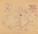
| Date: | 12 1900 |
|---|---|
| Description: | This manuscript map from 1900 shows resorts, lakes, rivers and streams, roads, railroads, and telephone lines in northwest Vilas County, in the towns of Bo... |

| Date: | 1941 |
|---|---|
| Description: | This 1941 map covers Washburn County, Wisconsin, as well as western Sawyer, eastern Burnett, and northeastern Polk counties. It shows the locations of tour... |

| Date: | 1955 |
|---|---|
| Description: | This 1950s tourist brochure features a map of Burnett County, Wisconsin, and northern Polk County which shows highways and roads, railroads, landmarks, and... |

| Date: | 1991 |
|---|---|
| Description: | This 1991 map of Burnett County, Wisconsin, shows Governor Knowles State Forest, wildlife areas, public hunting grounds, and other outdoor recreation facil... |

| Date: | 1956 |
|---|---|
| Description: | This map shows Lake Wisconsin, roads, highways, parks, resort areas, camps, gardens, and Wisconsin State experimental game and fur farm. The back of the ma... |

| Date: | 1941 |
|---|---|
| Description: | This is map one of three maps that show trails, roads and fire lanes, utilities, resorts, submerged lakes, vegetation, flowage right lands, and timber righ... |

| Date: | 1941 |
|---|---|
| Description: | This is map three of a set of three, and shows trails, roads and fire lanes, utilities, resorts, submerged lakes, vegetation, flowage right lands, and timb... |

| Date: | 1952 |
|---|---|
| Description: | This map shows roads, foot and canoe trails, railroads, resorts, lookout towers, camps, national and state forests, Indian reservation, and types of fish i... |

| Date: | 1918 |
|---|---|
| Description: | This map shows counties, cities, towns, villages, summer resorts, lakes, rivers, creeks, wagon roads, roads, railroads, and electric lines. The authentic a... |

| Date: | 1900 |
|---|---|
| Description: | This map shows logging roads, railroads with spur lines, trails, rapids, lumber camps, Indian villages, summer resort, lakes, rivers, and ponds. |

| Date: | 1935 |
|---|---|
| Description: | This blue lined map ("compliments of Black Eagle Oil Company") shows the major roads and cities of Wisconsin. The map includes an index, hotel and cafe adv... |

| Date: | 1940 |
|---|---|
| Description: | This map shows lakes, roads, car trails, foot trails, railroads, resorts and camps, and fire towers. The map includes an inset location map and pictorial d... |

| Date: | 1975 |
|---|---|
| Description: | This map shows nature trails, public attractions, public hunting and fishing grounds, dams, waysides, lakes, highways, and roads. The upper right corner in... |

| Date: | 1994 |
|---|---|
| Description: | This map shows historical sites, picnic grounds, public boat landings, canoe and motor boat trips, and resort locations. The left margin of the map include... |

| Date: | 1962 |
|---|---|
| Description: | This tourist-oriented road map shows federal highways, state highways, county roads, and county lines in the "Blue Diamond Resort Area," a scenic space enc... |
If you didn't find the material you searched for, our Library Reference Staff can help.
Call our reference desk at 608-264-6535 or email us at: