Filter: Subject of resorts
Filter: Subject of roads
Filter: Subject of resorts
Filter: Subject of roads

| Date: | 1890 |
|---|---|
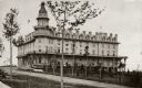
| Description: | Colored bird's-eye map of Oconomowoc and the Lake Region, Waukesha County. Looking North from Government Hill. Location key below image identifies 24 Hotel... |
| Date: | 1911 |
|---|---|
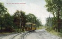
| Description: | Colorized view of the railroad curve near Whitefish Bay resort. Caption reads: "The Curve near Whitefish Bay Resort." |
| Date: | 07 03 1947 |
|---|---|
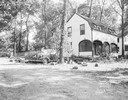
| Description: | Car, wrecked by falling tree, parked next to a house at Edwards Park. The tree has been removed and sawed into pieces. |

| Date: | 1920 |
|---|---|
| Description: | View of the main building of the Moor (Mud) Baths. Caption reads: "Main Building, Waukesha Moor (Mud) Bath Co., Waukesha, Wis. 'Open all the year 'round.'" |
| Date: | |
|---|---|
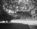
| Description: | View of Dering's Resort, located in a wooded area. In the foreground is a road, and on the other side is a resort cabin with a small garden and bird bath. |
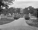
| Date: | 04 1925 |
|---|---|
| Description: | View of the wood trellis fence and columns that frame the entrance gate to the Silver-Dale Resort. A group of people are sitting on the porch of a refreshm... |
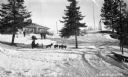
| Date: | 1935 |
|---|---|
| Description: | Winter scene with people sledding, dog sledding, snowshoeing, and preparing for snowshoeing at Lakewood Country Club. |

| Date: | 1958 |
|---|---|
| Description: | Includes images of Flambeau River State Forest and a description of, canoeing and recreational activities in, and general park and forest information about... |

| Date: | 1891 |
|---|---|
| Description: | A hand-colored map of Milwaukee County, Wisconsin that shows the township and range system, sections, towns, roads, railroads and rail stations, cities and... |

| Date: | 1932 |
|---|---|
| Description: | View of Gateway to Bobynn on Lake Namakagon, labeled as Cable and Grand View, Wisconsin. In front is a dirt road with two signs that read "The Bobynn." Beh... |

| Date: | 1926 |
|---|---|
| Description: | This 1926 map depicts resorts and camps, lakes and streams, railroads, and roads in portions of Vilas, Iron, Oneida, Price, and Lincoln counties in Wiscons... |

| Date: | 1974 |
|---|---|
| Description: | This 1968 map identifies resorts in the Lac du Flambeau Indian Reservation region of Wisconsin, covering parts of Iron, Vilas, Oneida, and Price counties. ... |

| Date: | 1941 |
|---|---|
| Description: | This 1941 map covers Washburn County, Wisconsin, as well as western Sawyer, eastern Burnett, and northeastern Polk counties. It shows the locations of tour... |

| Date: | 1955 |
|---|---|
| Description: | This 1950s tourist brochure features a map of Burnett County, Wisconsin, and northern Polk County which shows highways and roads, railroads, landmarks, and... |

| Date: | 1909 |
|---|---|
| Description: | This 1909 map of northern Wisconsin and a portion of Michigan's Upper Peninsula shows the Lac du Flambeau Indian Reservation, cities and villages, railroad... |

| Date: | 1929 |
|---|---|
| Description: | View across road of cottage with a screened porch in a wooded area. Picnic tables are on the left. A bench is in front of the cottage. A row of planters in... |
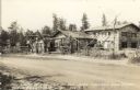
| Date: | |
|---|---|
| Description: | Photographic postcard view of a log resort and filling station on the side of a dirt road. Caption reads: "The House by the Side of the Road — Fallhall Gle... |

| Date: | |
|---|---|
| Description: | View across road towards the stone steps leading up a hill to the main building of the Birchcliff Hotel. A lawn swing is on top of the hill to the left of ... |
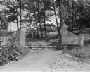
| Date: | 1927 |
|---|---|
| Description: | Front entrance to the Black Oaks resort. A man is driving an automobile down the drive near two stone walls with columns framing the entrance to the drivew... |
If you didn't find the material you searched for, our Library Reference Staff can help.
Call our reference desk at 608-264-6535 or email us at: