 Filter: Subject of resorts
Filter: Subject of roads
Filter: Subject of resorts
Filter: Subject of roads

| Date: | 1958 |
|---|---|
| Description: | Includes images of Flambeau River State Forest and a description of, canoeing and recreational activities in, and general park and forest information about... |

| Date: | 1916 |
|---|---|
| Description: | This map shows the locations of hunting and fishing resorts in the northern Wisconsin counties of Forest, Iron, Oneida, and Vilas, and in Gogebic County in... |
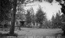
| Date: | 1932 |
|---|---|
| Description: | View down dirt driveway lined with stones leading up to a main building at Leibman's Resort on Lake Chippewa. Two automobiles are parked off to the far rig... |

| Date: | 1935 |
|---|---|
| Description: | View looking down a dirt road. Two cabins and an automobile are visible through the trees at Pine Gable's on Lake Owen. |

| Date: | |
|---|---|
| Description: | Letterhead of the Riverside Sanitarium of Milwaukee, Wisconsin, with a view of the grounds, including three sanitarium buildings, and rows of trees in the ... |
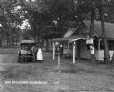
| Date: | 1929 |
|---|---|
| Description: | A man, woman, and child pose by a car near a tourist camping stop. |

| Date: | 1931 |
|---|---|
| Description: | View down driveway of the entrance sign to the Evergreen Retreat. In the background an automobile is parked near buildings and a flag on a flagpole. |
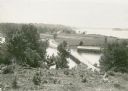
| Date: | |
|---|---|
| Description: | Elevated view overlooking a road leading toward water, a boathouse, cabins, and a lake, most likely Jackson Lake. The shoreline on the far top right is ide... |
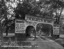
| Date: | 1929 |
|---|---|
| Description: | The entrance way to the Evergreen Resort. The sign advertises rooms, hot and cold water baths, meals, camp sites, and tourist kitchens. Caption reads: "Eve... |

| Date: | 1950 |
|---|---|
| Description: | This road map shows federal, state and county roads in Wisconsin, northern Illinois, northeastern Iowa, eastern Minnesota, and the western portion of Michi... |

| Date: | 1891 |
|---|---|
| Description: | A hand-colored map of Milwaukee County, Wisconsin that shows the township and range system, sections, towns, roads, railroads and rail stations, cities and... |

| Date: | 1915 |
|---|---|
| Description: | This 1915 map shows railroads, wagon roads, trails, creeks, rivers, lakes, and trout streams in Oneida and Lincoln counties within a 12 mile radius of Rhin... |

| Date: | 1914 |
|---|---|
| Description: | This 1914 map of Price County, Wisconsin, shows land for sale by the Good Land Company and Dewitt van Ostrand of Phillips. Also shown are the township and ... |

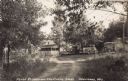
| Date: | 1932 |
|---|---|
| Description: | View of Gateway to Bobynn on Lake Namakagon, labeled as Cable and Grand View, Wisconsin. In front is a dirt road with two signs that read "The Bobynn." Beh... |
| Date: | 1933 |
|---|---|
| Description: | Four automobiles parked at the top of a dirt drive at Pease Resort on Upper Eau Claire Lake. On the far right is a shed or garage, and on the left are tree... |

| Date: | 1949 |
|---|---|
| Description: | This 1949 tourism brochure for the Hayward region includes a directory of members of the Hayward Lakes Resort Association, color illustrations, descriptive... |
| Date: | 12 1900 |
|---|---|
| Description: | This manuscript map from 1900 shows resorts, lakes, rivers and streams, roads, railroads, and telephone lines in northwest Vilas County, in the towns of Bo... |

| Date: | 1926 |
|---|---|
| Description: | This 1926 map depicts resorts and camps, lakes and streams, railroads, and roads in portions of Vilas, Iron, Oneida, Price, and Lincoln counties in Wiscons... |

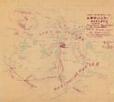
| Date: | 1974 |
|---|---|
| Description: | This 1968 map identifies resorts in the Lac du Flambeau Indian Reservation region of Wisconsin, covering parts of Iron, Vilas, Oneida, and Price counties. ... |

| Date: | 1941 |
|---|---|
| Description: | This 1941 map covers Washburn County, Wisconsin, as well as western Sawyer, eastern Burnett, and northeastern Polk counties. It shows the locations of tour... |
If you didn't find the material you searched for, our Library Reference Staff can help.
Call our reference desk at 608-264-6535 or email us at: