 Filter: Subject of resorts
Filter: Subject of tourism
Filter: Subject of camps
Filter: Subject of resorts
Filter: Subject of tourism
Filter: Subject of camps
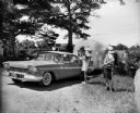
| Date: | 06 1959 |
|---|---|
| Description: | Two men with cameras around their necks stand near a couple in a Plymouth pulling an airstream camper through a gate. The sign on the gate in the backgroun... |

| Date: | 1926 |
|---|---|
| Description: | This 1926 map depicts resorts and camps, lakes and streams, railroads, and roads in portions of Vilas, Iron, Oneida, Price, and Lincoln counties in Wiscons... |
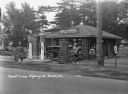
| Date: | 1931 |
|---|---|
| Description: | A view of the Log Cabin Filling Station at a tourist camp. A garage for washing and greasing on the left. Two tall gas pumps. Lamps made of interlaced logs... |

| Date: | 1939 |
|---|---|
| Description: | This brochure was intended for tourists and shows resorts, lakes and railroads in northwestern Wisconsin and part of Michigan’s upper peninsula. Also inclu... |

| Date: | 1969 |
|---|---|
| Description: | This map shows ski areas, resorts, camps, special areas, airports, and roads. The map covers Vilas and Oneida counties and parts of Iron, Price, Lincoln, L... |

| Date: | 1940 |
|---|---|
| Description: | This map shows lakes, roads, car trails, foot trails, railroads, resorts and camps, and fire towers. The map includes an inset location map and pictorial d... |
If you didn't find the material you searched for, our Library Reference Staff can help.
Call our reference desk at 608-264-6535 or email us at: