 Filter: Subject of resorts
Filter: Subject of tourism
Filter: Subject of economics
Filter: Subject of resorts
Filter: Subject of tourism
Filter: Subject of economics

| Date: | 1886 |
|---|---|
| Description: | Bird's-eye map of Baraboo with inset of Devil's Lake, the south and east sides of the commercial square, the First National Bank, and the Warren House hote... |
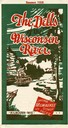
| Date: | 1928 |
|---|---|
| Description: | "The Dells," a brochure issued by the Chicago, Milwaukee & St. Paul and Pacific Railroad to advertise the Wisconsin Dells, a destination only five hours fr... |
| Date: | |
|---|---|
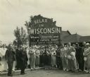
| Description: | Group of resort and hotel owners gathered in front of a Wisconsin tourism sign that reads: "Relax In Wisconsin." There is a building in the background. |

| Date: | 1910 |
|---|---|
| Description: | Cover of brochure for Old Timer's Resort (formerly Burke's Resort). |

| Date: | 1924 |
|---|---|
| Description: | The main building at Springhill Cottages, with a screened-in porch and a large billboard in front advertising cottages and rooms with private baths. |

| Date: | 1961 |
|---|---|
| Description: | This map shows the lake, clubs, resorts, motels, school house, public approaches, and public parks. The back of map includes advertisements and text. |

| Date: | 1935 |
|---|---|
| Description: | This blue lined map shows the major roads and cities of Wisconsin. The map includes an index, hotel and cafe advertisements, as well as advertisements for ... |

| Date: | 1935 |
|---|---|
| Description: | This blue lined map ("compliments of Black Eagle Oil Company") shows the major roads and cities of Wisconsin. The map includes an index, hotel and cafe adv... |

| Date: | 1975 |
|---|---|
| Description: | This map shows nature trails, public attractions, public hunting and fishing grounds, dams, waysides, lakes, highways, and roads. The upper right corner in... |

| Date: | 1943 |
|---|---|
| Description: | This map shows roads, trails, taverns, schools, golf, gas stations, campsites, resorts, and towers. The lower left of the map includes a legend. The map co... |

| Date: | 1991 |
|---|---|
| Description: | This map shows public access, fish crib locations, resorts, and other local businesses as well as advertisements for local attractions and a resort index. ... |
If you didn't find the material you searched for, our Library Reference Staff can help.
Call our reference desk at 608-264-6535 or email us at: