 Filter: Subject of resorts
Filter: Subject of tourism
Filter: Subject of outdoor recreation
Filter: Subject of resorts
Filter: Subject of tourism
Filter: Subject of outdoor recreation

| Date: | 1925 |
|---|---|
| Description: | This brochure intended for tourists and shows resorts, lakes and railroads in northwestern Wisconsin and part of Michigan’s upper peninsula. Two inset maps... |

| Date: | 1958 |
|---|---|
| Description: | Includes images of Flambeau River State Forest and a description of, canoeing and recreational activities in, and general park and forest information about... |

| Date: | 1949 |
|---|---|
| Description: | This 1949 tourism brochure for the Hayward region includes a directory of members of the Hayward Lakes Resort Association, color illustrations, descriptive... |
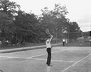
| Date: | |
|---|---|
| Description: | Two men playing tennis on the Birchcliff Hotel tennis court. Another group of guests are playing croquet on the lawn in the background. People relax on cha... |

| Date: | 1939 |
|---|---|
| Description: | This brochure was intended for tourists and shows resorts, lakes and railroads in northwestern Wisconsin and part of Michigan’s upper peninsula. Also inclu... |

| Date: | 1969 |
|---|---|
| Description: | This map shows ski areas, resorts, camps, special areas, airports, and roads. The map covers Vilas and Oneida counties and parts of Iron, Price, Lincoln, L... |

| Date: | 1977 |
|---|---|
| Description: | This colored map displays Wisconsin and portions of bordering states, including a detailed map of the Wisconsin Dells area. Surrounding the map are multipl... |
If you didn't find the material you searched for, our Library Reference Staff can help.
Call our reference desk at 608-264-6535 or email us at: