 Filter: Subject of resorts
Filter: Subject of tourism
Filter: Subject of roads
Filter: Subject of resorts
Filter: Subject of tourism
Filter: Subject of roads
| Date: | |
|---|---|
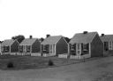
| Description: | View across road toward a row of four tiny, identical tourist cabins, with more cabins in the background. |
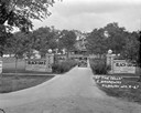
| Date: | 04 1925 |
|---|---|
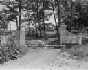
| Description: | View of the wood trellis fence and columns that frame the entrance gate to the Silver-Dale Resort. A group of people are sitting on the porch of a refreshm... |
| Date: | 1931 |
|---|---|
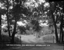
| Description: | View of the entrance to the Devi-Bara Resort. There is sign on the fence that reads, "Saddle Horses - 1/2 block" and another sign on a tree denoting that t... |
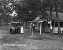
| Date: | 1930 |
|---|---|
| Description: | View of the entrance to Devil's Lake State Park. There is an information center offering gas, food, and Blatz beer. Two storekeepers and a boy sit on the p... |
| Date: | 1929 |
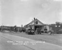
|---|---|
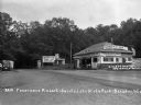
| Description: | Exterior view from road of gas station and "dine and dance" restaurant on Highway US-18/US-12, outside the Triangle Tourist Park. The establishment offers ... |

| Date: | 1958 |
|---|---|
| Description: | Includes images of Flambeau River State Forest and a description of, canoeing and recreational activities in, and general park and forest information about... |
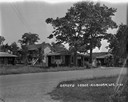
| Date: | 1929 |
|---|---|
| Description: | A man, woman, and child pose by a car near a tourist camping stop. |

| Date: | 1950 |
|---|---|
| Description: | This road map shows federal, state and county roads in Wisconsin, northern Illinois, northeastern Iowa, eastern Minnesota, and the western portion of Michi... |

| Date: | 1915 |
|---|---|
| Description: | This 1915 map shows railroads, wagon roads, trails, creeks, rivers, lakes, and trout streams in Oneida and Lincoln counties within a 12 mile radius of Rhin... |

| Date: | 1949 |
|---|---|
| Description: | This 1949 tourism brochure for the Hayward region includes a directory of members of the Hayward Lakes Resort Association, color illustrations, descriptive... |

| Date: | 1926 |
|---|---|
| Description: | This 1926 map depicts resorts and camps, lakes and streams, railroads, and roads in portions of Vilas, Iron, Oneida, Price, and Lincoln counties in Wiscons... |

| Date: | 1941 |
|---|---|
| Description: | This 1941 map covers Washburn County, Wisconsin, as well as western Sawyer, eastern Burnett, and northeastern Polk counties. It shows the locations of tour... |

| Date: | 1955 |
|---|---|
| Description: | This 1950s tourist brochure features a map of Burnett County, Wisconsin, and northern Polk County which shows highways and roads, railroads, landmarks, and... |

| Date: | 1930 |
|---|---|
| Description: | This manuscript map, likely drawn in the 1930s, shows Fox Lake, in Dodge County, Wisconsin, and the roads and resorts in the vicinity. |

| Date: | |
|---|---|
| Description: | View across road towards the stone steps leading up a hill to the main building of the Birchcliff Hotel. A lawn swing is on top of the hill to the left of ... |
| Date: | 1927 |
|---|---|
| Description: | Front entrance to the Black Oaks resort. A man is driving an automobile down the drive near two stone walls with columns framing the entrance to the drivew... |
| Date: | 1927 |
|---|---|
| Description: | View across road towards the office, filling station and cabin at Brady's Lodge. Two men stand near the gas pumps in front of a porch of an open counter se... |

| Date: | 1927 |
|---|---|
| Description: | Filling station and office at Brady's Lodge. An attendant is standing by the gas pump. There is a truck parked on the right. Signs on the left read: "Sandw... |
| Date: | 1926 |
|---|---|
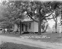
| Description: | Guest cottage with two doors in front, and a man sitting on the stoop. There are automobiles parked on the left. |

| Date: | |
|---|---|
| Description: | Group portrait of five riders on horses posing on the road in front of two guest cottages. A young girl is standing on the left. |
If you didn't find the material you searched for, our Library Reference Staff can help.
Call our reference desk at 608-264-6535 or email us at: