 Filter: Subject of resorts
Filter: Subject of tourism
Filter: Subject of resorts
Filter: Subject of tourism

| Date: | 07 14 1958 |
|---|---|
| Description: | Photographic postcard of a cottage path at Syd's Resort of the Woods. Many cottages can be seen through the trees, and a lawn swing is on the right. Many o... |

| Date: | 1925 |
|---|---|
| Description: | This brochure intended for tourists and shows resorts, lakes and railroads in northwestern Wisconsin and part of Michigan’s upper peninsula. Two inset maps... |
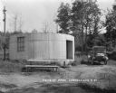
| Date: | 1927 |
|---|---|
| Description: | A cylinder-shaped cement building with an open door in a rural area. In front of the building is a picnic table, and on the right an automobile is parked n... |
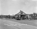
| Date: | 1929 |
|---|---|
| Description: | Exterior view from road of gas station and "dine and dance" restaurant on Highway US-18/US-12, outside the Triangle Tourist Park. The establishment offers ... |
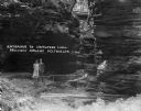
| Date: | 1925 |
|---|---|
| Description: | A man and woman pose at the wooden walkway among the rock formations of Congress Hall, on the Dell View Resort property. |

| Date: | 1930 |
|---|---|
| Description: | Three chairs around a table with stacks of books in the lobby of the Silver Dale Resort at Devil's Lake. In the background three open doors lead into the d... |

| Date: | 1930 |
|---|---|
| Description: | View of dining room tables placed at an angle along a row of windows. The tables are set with silverware, plates, cups, pitchers, and menus. On the back wa... |

| Date: | 1958 |
|---|---|
| Description: | Includes images of Flambeau River State Forest and a description of, canoeing and recreational activities in, and general park and forest information about... |
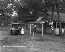
| Date: | 1929 |
|---|---|
| Description: | A man, woman, and child pose by a car near a tourist camping stop. |
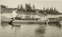
| Date: | |
|---|---|
| Description: | View of a man paddling a canoe with a woman sitting in the front holding an umbrella and white water lily. The canoe says "Nature Lovers Paradise." Text de... |

| Date: | |
|---|---|
| Description: | Letterhead of Denton House of Eagle River, Wisconsin, with a profile view of a fish printed in brown ink across nearly the entire width of the page, and th... |

| Date: | 1950 |
|---|---|
| Description: | This road map shows federal, state and county roads in Wisconsin, northern Illinois, northeastern Iowa, eastern Minnesota, and the western portion of Michi... |

| Date: | 1915 |
|---|---|
| Description: | This 1915 map shows railroads, wagon roads, trails, creeks, rivers, lakes, and trout streams in Oneida and Lincoln counties within a 12 mile radius of Rhin... |

| Date: | 1949 |
|---|---|
| Description: | This 1949 tourism brochure for the Hayward region includes a directory of members of the Hayward Lakes Resort Association, color illustrations, descriptive... |

| Date: | 1977 |
|---|---|
| Description: | This pictorial map was produced by the Chateau, a resort in La Pointe, and shows Madeline Island landmarks and tourist attractions. On the verso is the spr... |

| Date: | 1926 |
|---|---|
| Description: | This 1926 map depicts resorts and camps, lakes and streams, railroads, and roads in portions of Vilas, Iron, Oneida, Price, and Lincoln counties in Wiscons... |

| Date: | 1941 |
|---|---|
| Description: | This 1941 map covers Washburn County, Wisconsin, as well as western Sawyer, eastern Burnett, and northeastern Polk counties. It shows the locations of tour... |

| Date: | 1955 |
|---|---|
| Description: | This 1950s tourist brochure features a map of Burnett County, Wisconsin, and northern Polk County which shows highways and roads, railroads, landmarks, and... |

| Date: | 1938 |
|---|---|
| Description: | This tourist map of Door County, Wisconsin, lists the points of interest and resorts in the area. An inset location map is included. |

| Date: | 1938 |
|---|---|
| Description: | This 1938 tourist map of Douglas County, Wisconsin, identifies game refuges, fishing locations, and other outdoor recreation opportunities in the county. A... |
If you didn't find the material you searched for, our Library Reference Staff can help.
Call our reference desk at 608-264-6535 or email us at: