 Filter: Subject of resorts
Filter: Subject of trails
Filter: Subject of tourism
Filter: Subject of resorts
Filter: Subject of trails
Filter: Subject of tourism
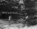
| Date: | 1925 |
|---|---|
| Description: | A man and woman pose at the wooden walkway among the rock formations of Congress Hall, on the Dell View Resort property. |

| Date: | 1941 |
|---|---|
| Description: | This 1941 map covers Washburn County, Wisconsin, as well as western Sawyer, eastern Burnett, and northeastern Polk counties. It shows the locations of tour... |

| Date: | 1926 |
|---|---|
| Description: | View of grounds with a large guest cottage with large front porch on the right. On the left is a three-story structure shaped like a tower. |

| Date: | 1940 |
|---|---|
| Description: | This map shows lakes, roads, car trails, foot trails, railroads, resorts and camps, and fire towers. The map includes an inset location map and pictorial d... |

| Date: | 1975 |
|---|---|
| Description: | This map shows nature trails, public attractions, public hunting and fishing grounds, dams, waysides, lakes, highways, and roads. The upper right corner in... |

| Date: | 1943 |
|---|---|
| Description: | This map shows roads, trails, taverns, schools, golf, gas stations, campsites, resorts, and towers. The lower left of the map includes a legend. The map co... |

| Date: | 1991 |
|---|---|
| Description: | This map shows public access, fish crib locations, resorts, and other local businesses as well as advertisements for local attractions and a resort index. ... |
If you didn't find the material you searched for, our Library Reference Staff can help.
Call our reference desk at 608-264-6535 or email us at: