 Filter: Subject of resorts
Filter: Subject of trails
Filter: Year of 1900-1999
Filter: Subject of resorts
Filter: Subject of trails
Filter: Year of 1900-1999
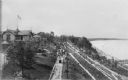
| Date: | 1914 |
|---|---|
| Description: | Elevated view of Pabst Whitefish Bay Resort on the shores of Lake Michigan, with crowds of individuals walking up the numerous paths that lead to the resor... |
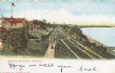
| Date: | 1905 |
|---|---|
| Description: | Elevated view of people walking on a path by the Whitefish Bay Resort along the lake front. Caption reads: "Whitefish Bay Resort, Milwaukee." |
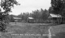
| Date: | 1938 |
|---|---|
| Description: | Cabins around clearing in the woods at Lyndale Bay Resort on Upper Eau Claire Lake. |

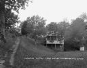
| Date: | 1937 |
|---|---|
| Description: | House, garage, and cottage on shoreline of Diamond Lake. |
| Date: | 1926 |
|---|---|
| Description: | A cottage with a "Hill-Side" sign. An outhouse is to the right of the cottage. There is a path up the hill on the left. |
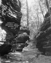
| Date: | 1925 |
|---|---|
| Description: | Rock formations at Congress Hall on the Dell View Resort property. |
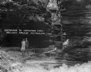
| Date: | 1925 |
|---|---|
| Description: | A man and woman pose at the wooden walkway among the rock formations of Congress Hall, on the Dell View Resort property. |
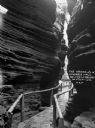
| Date: | 1925 |
|---|---|
| Description: | View down a narrow wooden walkway through rock formations at Congress Hall, on the Dell View Resort property. |

| Date: | 1916 |
|---|---|
| Description: | This map shows the locations of hunting and fishing resorts in the northern Wisconsin counties of Forest, Iron, Oneida, and Vilas, and in Gogebic County in... |

| Date: | 1904 |
|---|---|
| Description: | A map that shows the location of the lakes and resorts in northeastern Wisconsin that were reachable by the Chicago and North Western Railway. Shown in the... |

| Date: | 1974 |
|---|---|
| Description: | This 1968 map identifies resorts in the Lac du Flambeau Indian Reservation region of Wisconsin, covering parts of Iron, Vilas, Oneida, and Price counties. ... |

| Date: | 1941 |
|---|---|
| Description: | This 1941 map covers Washburn County, Wisconsin, as well as western Sawyer, eastern Burnett, and northeastern Polk counties. It shows the locations of tour... |

| Date: | 1909 |
|---|---|
| Description: | This 1909 map of northern Wisconsin and a portion of Michigan's Upper Peninsula shows the Lac du Flambeau Indian Reservation, cities and villages, railroad... |

| Date: | 1926 |
|---|---|
| Description: | View of grounds with a large guest cottage with large front porch on the right. On the left is a three-story structure shaped like a tower. |

| Date: | 1941 |
|---|---|
| Description: | This is map one of three maps that show trails, roads and fire lanes, utilities, resorts, submerged lakes, vegetation, flowage right lands, and timber righ... |

| Date: | 1952 |
|---|---|
| Description: | This map shows roads, foot and canoe trails, railroads, resorts, lookout towers, camps, national and state forests, Indian reservation, and types of fish i... |

| Date: | 1900 |
|---|---|
| Description: | This map shows logging roads, railroads with spur lines, trails, rapids, lumber camps, Indian villages, summer resort, lakes, rivers, and ponds. |

| Date: | 1940 |
|---|---|
| Description: | This map shows lakes, roads, car trails, foot trails, railroads, resorts and camps, and fire towers. The map includes an inset location map and pictorial d... |

| Date: | 1975 |
|---|---|
| Description: | This map shows nature trails, public attractions, public hunting and fishing grounds, dams, waysides, lakes, highways, and roads. The upper right corner in... |

| Date: | 1943 |
|---|---|
| Description: | This map shows roads, trails, taverns, schools, golf, gas stations, campsites, resorts, and towers. The lower left of the map includes a legend. The map co... |
If you didn't find the material you searched for, our Library Reference Staff can help.
Call our reference desk at 608-264-6535 or email us at: