 Filter: Subject of resorts
Filter: Subject of transportation
Filter: Subject of church buildings
Filter: Subject of resorts
Filter: Subject of transportation
Filter: Subject of church buildings
| Date: | |
|---|---|
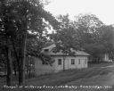
| Description: | A hexagon-shaped chapel along the dirt road. |

| Date: | 1891 |
|---|---|
| Description: | A hand-colored map of Milwaukee County, Wisconsin that shows the township and range system, sections, towns, roads, railroads and rail stations, cities and... |

| Date: | 1914 |
|---|---|
| Description: | This 1914 map of Price County, Wisconsin, shows land for sale by the Good Land Company and Dewitt van Ostrand of Phillips. Also shown are the township and ... |
If you didn't find the material you searched for, our Library Reference Staff can help.
Call our reference desk at 608-264-6535 or email us at: