 Filter: Subject of rivers
Filter: Subject of african americans
Filter: Subject of rivers
Filter: Subject of african americans

| Date: | 02 21 1874 |
|---|---|
| Description: | African American boatmen run a rapids in a small river boat. |
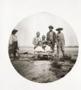
| Date: | 06 02 1894 |
|---|---|
| Description: | A group of children pose with a small cart. |
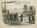
| Date: | 02 28 1863 |
|---|---|
| Description: | The First Regiment of the Louisiana Native Guards disembarking at Fort Macomb, Louisiana. The fort is adjacent to the Venetian Isles community, now legally... |

| Date: | |
|---|---|
| Description: | View across river toward four African American men posed standing and squatting on the opposite riverbank of the Saw Mill River. Buildings are among trees ... |
| Date: | |
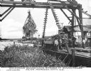
|---|---|
| Description: | View of several men unloading a barge of sugar cane with a crane-like tool. A river and dock area are in the background. Caption reads: "Unloading Sugar Ca... |

| Date: | |
|---|---|
| Description: | Two views, one of a ferry and the other of a chain gang. The ferry operator poses with a man in his carriage on the ferry, with trees in the background. Th... |
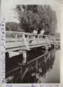
| Date: | 1920 |
|---|---|
| Description: | Andrew Webb Jr. and Al. Weaver standing on a bridge over the "Catfish" (Yahara) River in Tenney Park. |
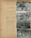
| Date: | 07 22 1941 |
|---|---|
| Description: | Scrapbook page of trip highlights from a bike hosteling trip to Pine Bluff (Dane County), Sauk City (Sauk County), and Okee (Columbia County), sponsored by... |
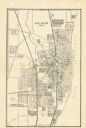
| Date: | 1947 |
|---|---|
| Description: | This map of Racine has labeled streets, the Root River, Lake Michigan, and includes manuscript annotations of newly annexed areas and African-American neig... |

| Date: | 1783 |
|---|---|
| Description: | This map is hand-colored and shows the boundaries of British, Spanish, and the newly recognized American claims, as well as the fishing rights granted to F... |

| Date: | 1755 |
|---|---|
| Description: | Map of Virginia and parts of Maryland, North Carolina, and New Jersey. It shows borders, boundary lines, some Native American land, counties, cities, towns... |

| Date: | 1918 |
|---|---|
| Description: | Elevated view of Slabtown/Flora Fountain. The church in the lower right was built by the Latter Day Saints and later moved to Lancaster. |
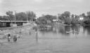
| Date: | 06 1938 |
|---|---|
| Description: | View across water on a sunny day, where many anglers are fishing below the Indian Ford dam and bridge on the Rock river. Some of the men are fishing from t... |

| Date: | |
|---|---|
| Description: | Stereograph of a demolished railroad bridge, most likely over the Rock River. Several men are standing on a horizontal section. In the bottom right corner,... |
If you didn't find the material you searched for, our Library Reference Staff can help.
Call our reference desk at 608-264-6535 or email us at: